You are here: Home > Network List > TA - USArray Transportable Network (new EarthScope stations) Stations List
> Station W18A Petrified Forest, AZ, USA > Earthquake Result Viewer
W18A Petrified Forest, AZ, USA - Earthquake Result Viewer
| Earthquake location: |
Near Coast Of Ecuador |
| Earthquake latitude/longitude: |
0.4/-79.8 |
| Earthquake time(UTC): |
2016/05/18 (139) 07:57:05 GMT |
| Earthquake Depth: |
32 km |
| Earthquake Magnitude: |
6.7 MWP, 6.7 MWW, 6.7 MI |
| Earthquake Catalog/Contributor: |
NEIC PDE/NEIC COMCAT |
|
| Network: |
TA USArray Transportable Network (new EarthScope stations) |
| Station: |
W18A Petrified Forest, AZ, USA |
| Lat/Lon: |
35.12 N/109.74 W |
| Elevation: |
1750 m |
|
| Distance: |
44.4 deg |
| Az: |
324.179 deg |
| Baz: |
134.448 deg |
| Ray Param: |
0.07187372 |
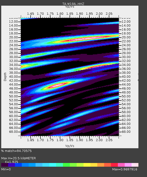
| Estimated Moho Depth: |
20.5 km |
| Estimated Crust Vp/Vs: |
1.92 |
| Assumed Crust Vp: |
6.496 km/s |
| Estimated Crust Vs: |
3.375 km/s |
| Estimated Crust Poisson's Ratio: |
0.32 |
|
| Radial Match: |
94.70575 % |
| Radial Bump: |
221 |
| Transverse Match: |
82.274124 % |
| Transverse Bump: |
338 |
| SOD ConfigId: |
7422571 |
| Insert Time: |
2019-04-22 14:44:55.430 +0000 |
| GWidth: |
2.5 |
| Max Bumps: |
400 |
| Tol: |
0.001 |
|

Signal To Noise
| Channel | StoN | STA | LTA |
| TA:W18A: :HHZ:20160518T08:04:41.470002Z | 6.7386236 | 6.4894635E-7 | 9.63025E-8 |
| TA:W18A: :HHN:20160518T08:04:41.470002Z | 2.9178178 | 2.574673E-7 | 8.8239666E-8 |
| TA:W18A: :HHE:20160518T08:04:41.470002Z | 2.2351925 | 2.0513946E-7 | 9.177708E-8 |
| Arrivals |
| Ps | 3.1 SECOND |
| PpPs | 8.7 SECOND |
| PsPs/PpSs | 12 SECOND |


