SDCO Great Sand Dunes National Park, Colorado, USA - Earthquake Result Viewer
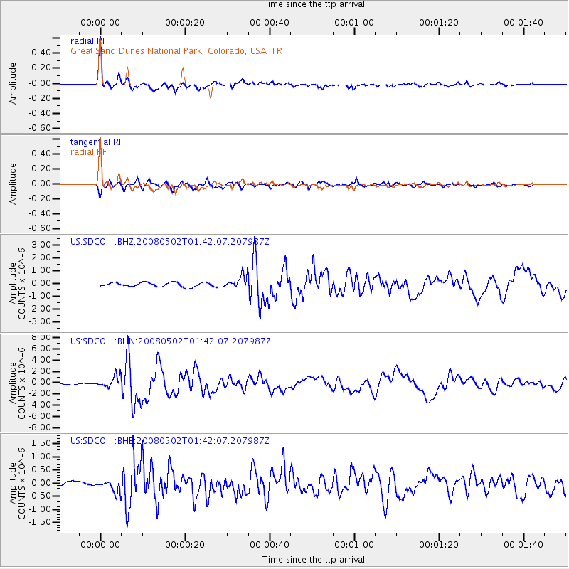
Earthquake location: Andreanof Islands, Aleutian Is.
Earthquake latitude/longitude: 51.9/-177.5
Earthquake time(UTC): 2008/05/02 (123) 01:33:37 GMT
Earthquake Depth: 14 km
Earthquake Magnitude: 6.3 MB, 6.8 MS, 6.6 MW, 6.6 MW
Earthquake Catalog/Contributor: WHDF/NEIC
Network: US United States National Seismic Network
Station: SDCO Great Sand Dunes National Park, Colorado, USA
Lat/Lon: 37.75 N/105.50 W
Elevation: 2569 m
Distance: 51.0 deg
Az: 76.136 deg
Baz: 310.584 deg
Ray Param: 0.067705624
Estimated Moho Depth: 16.25 km
Estimated Crust Vp/Vs: 1.60
Assumed Crust Vp: 6.316 km/s
Estimated Crust Vs: 3.947 km/s
Estimated Crust Poisson's Ratio: 0.18
Radial Match: 94.9356 %
Radial Bump: 357
Transverse Match: 91.38871 %
Transverse Bump: 400
SOD ConfigId: 2504
Insert Time: 2010-03-05 03:13:06.255 +0000
GWidth: 2.5
Max Bumps: 400
Tol: 0.001

Signal To Noise

ChannelStoNSTALTA
US:SDCO: :BHN:20080502T01:42:07.207987Z8.1895611.0494272E-61.2814206E-7
US:SDCO: :BHE:20080502T01:42:07.207987Z3.29141862.2801353E-76.927515E-8
US:SDCO: :BHZ:20080502T01:42:07.207987Z3.03761555.095771E-71.6775562E-7
Arrivals
Ps1.6 SECOND
PpPs6.3 SECOND
PsPs/PpSs7.9 SECOND