NEE2 Needles Airport - Earthquake Result Viewer
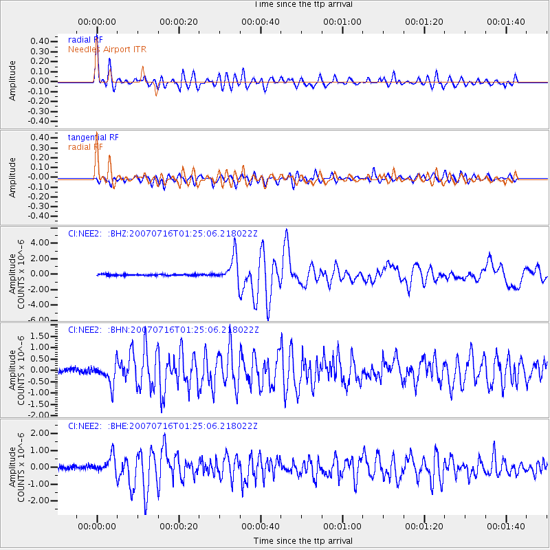
Earthquake location: Near West Coast Of Honshu, Japan
Earthquake latitude/longitude: 37.5/138.4
Earthquake time(UTC): 2007/07/16 (197) 01:13:22 GMT
Earthquake Depth: 12 km
Earthquake Magnitude: 6.5 MB, 6.4 MS, 6.6 MW, 6.5 MW
Earthquake Catalog/Contributor: WHDF/NEIC
Network: CI Caltech Regional Seismic Network
Station: NEE2 Needles Airport
Lat/Lon: 34.77 N/114.62 W
Elevation: 271 m
Distance: 81.2 deg
Az: 52.848 deg
Baz: 309.679 deg
Ray Param: 0.047781385
Estimated Moho Depth: 28.25 km
Estimated Crust Vp/Vs: 1.70
Assumed Crust Vp: 6.276 km/s
Estimated Crust Vs: 3.692 km/s
Estimated Crust Poisson's Ratio: 0.24
Radial Match: 92.70161 %
Radial Bump: 400
Transverse Match: 86.4001 %
Transverse Bump: 400
SOD ConfigId: 2564
Insert Time: 2010-02-26 00:22:41.614 +0000
GWidth: 2.5
Max Bumps: 400
Tol: 0.001

Signal To Noise

ChannelStoNSTALTA
CI:NEE2: :BHN:20070716T01:25:06.218022Z5.5599694.687796E-78.431335E-8
CI:NEE2: :BHE:20070716T01:25:06.218022Z4.56493045.478092E-71.2000383E-7
CI:NEE2: :BHZ:20070716T01:25:06.218022Z22.2877941.7970017E-68.062717E-8
Arrivals
Ps3.2 SECOND
PpPs12 SECOND
PsPs/PpSs15 SECOND