You are here: Home > Network List > UW - Pacific Northwest Regional Seismic Network Stations List
> Station LEBA Lebam, WA, USA > Earthquake Result Viewer
LEBA Lebam, WA, USA - Earthquake Result Viewer
| Earthquake location: |
Near Coast Of Ecuador |
| Earthquake latitude/longitude: |
0.4/-79.8 |
| Earthquake time(UTC): |
2016/05/18 (139) 07:57:05 GMT |
| Earthquake Depth: |
32 km |
| Earthquake Magnitude: |
6.7 MWP, 6.7 MWW, 6.7 MI |
| Earthquake Catalog/Contributor: |
NEIC PDE/NEIC COMCAT |
|
| Network: |
UW Pacific Northwest Regional Seismic Network |
| Station: |
LEBA Lebam, WA, USA |
| Lat/Lon: |
46.55 N/123.56 W |
| Elevation: |
73 m |
|
| Distance: |
59.8 deg |
| Az: |
326.433 deg |
| Baz: |
126.768 deg |
| Ray Param: |
0.06191795 |
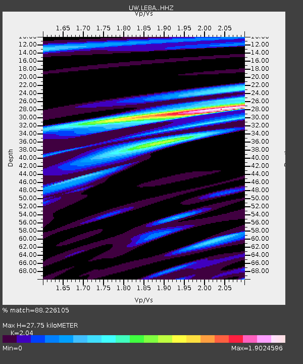
| Estimated Moho Depth: |
27.75 km |
| Estimated Crust Vp/Vs: |
2.04 |
| Assumed Crust Vp: |
6.566 km/s |
| Estimated Crust Vs: |
3.219 km/s |
| Estimated Crust Poisson's Ratio: |
0.34 |
|
| Radial Match: |
88.226105 % |
| Radial Bump: |
400 |
| Transverse Match: |
84.83075 % |
| Transverse Bump: |
400 |
| SOD ConfigId: |
7422571 |
| Insert Time: |
2019-04-22 14:45:34.318 +0000 |
| GWidth: |
2.5 |
| Max Bumps: |
400 |
| Tol: |
0.001 |
|
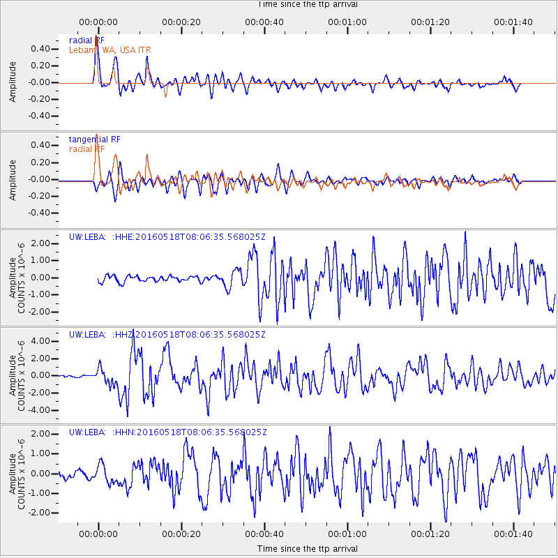
Signal To Noise
| Channel | StoN | STA | LTA |
| UW:LEBA: :HHZ:20160518T08:06:35.568025Z | 5.30823 | 9.4913287E-7 | 1.7880402E-7 |
| UW:LEBA: :HHN:20160518T08:06:35.568025Z | 2.5307553 | 4.62873E-7 | 1.8289917E-7 |
| UW:LEBA: :HHE:20160518T08:06:35.568025Z | 3.0786986 | 5.123693E-7 | 1.6642399E-7 |
| Arrivals |
| Ps | 4.6 SECOND |
| PpPs | 12 SECOND |
| PsPs/PpSs | 17 SECOND |


