You are here: Home > Network List > US - United States National Seismic Network Stations List
> Station SDCO Great Sand Dunes National Park, Colorado, USA > Earthquake Result Viewer
SDCO Great Sand Dunes National Park, Colorado, USA - Earthquake Result Viewer
| Earthquake location: |
Tonga Islands |
| Earthquake latitude/longitude: |
-21.9/-173.8 |
| Earthquake time(UTC): |
2008/10/19 (293) 05:10:33 GMT |
| Earthquake Depth: |
29 km |
| Earthquake Magnitude: |
6.8 MB, 7.0 MS, 6.9 MW, 6.9 MW |
| Earthquake Catalog/Contributor: |
WHDF/NEIC |
|
| Network: |
US United States National Seismic Network |
| Station: |
SDCO Great Sand Dunes National Park, Colorado, USA |
| Lat/Lon: |
37.75 N/105.50 W |
| Elevation: |
2569 m |
|
| Distance: |
87.3 deg |
| Az: |
47.513 deg |
| Baz: |
239.785 deg |
| Ray Param: |
0.04335945 |
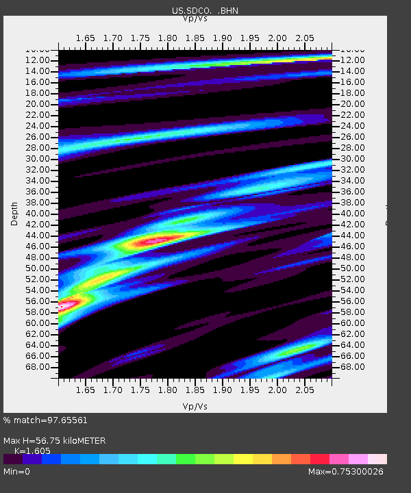
| Estimated Moho Depth: |
56.75 km |
| Estimated Crust Vp/Vs: |
1.61 |
| Assumed Crust Vp: |
6.316 km/s |
| Estimated Crust Vs: |
3.935 km/s |
| Estimated Crust Poisson's Ratio: |
0.18 |
|
| Radial Match: |
97.65561 % |
| Radial Bump: |
325 |
| Transverse Match: |
93.49832 % |
| Transverse Bump: |
386 |
| SOD ConfigId: |
2560 |
| Insert Time: |
2010-03-05 03:13:32.984 +0000 |
| GWidth: |
2.5 |
| Max Bumps: |
400 |
| Tol: |
0.001 |
|

Signal To Noise
| Channel | StoN | STA | LTA |
| US:SDCO: :BHN:20081019T05:22:46.730007Z | 64.3291 | 5.1179168E-6 | 7.955835E-8 |
| US:SDCO: :BHE:20081019T05:22:46.730007Z | 13.559222 | 1.1726811E-6 | 8.648586E-8 |
| US:SDCO: :BHZ:20081019T05:22:46.730007Z | 9.871135 | 1.0942417E-6 | 1.1085268E-7 |
| Arrivals |
| Ps | 5.6 SECOND |
| PpPs | 23 SECOND |
| PsPs/PpSs | 28 SECOND |


