You are here: Home > Network List > XD14 - Illuminating the architecture of the greater Mount St. Helens magmatic systems f Stations List
> Station MI02 "Mount St Helens, WA" > Earthquake Result Viewer
MI02 "Mount St Helens, WA" - Earthquake Result Viewer
| Earthquake location: |
Near Coast Of Ecuador |
| Earthquake latitude/longitude: |
0.4/-79.8 |
| Earthquake time(UTC): |
2016/05/18 (139) 07:57:05 GMT |
| Earthquake Depth: |
32 km |
| Earthquake Magnitude: |
6.7 MWP, 6.7 MWW, 6.7 MI |
| Earthquake Catalog/Contributor: |
NEIC PDE/NEIC COMCAT |
|
| Network: |
XD Illuminating the architecture of the greater Mount St. Helens magmatic systems f |
| Station: |
MI02 "Mount St Helens, WA" |
| Lat/Lon: |
46.22 N/122.67 W |
| Elevation: |
349 m |
|
| Distance: |
59.1 deg |
| Az: |
326.563 deg |
| Baz: |
127.482 deg |
| Ray Param: |
0.06237468 |
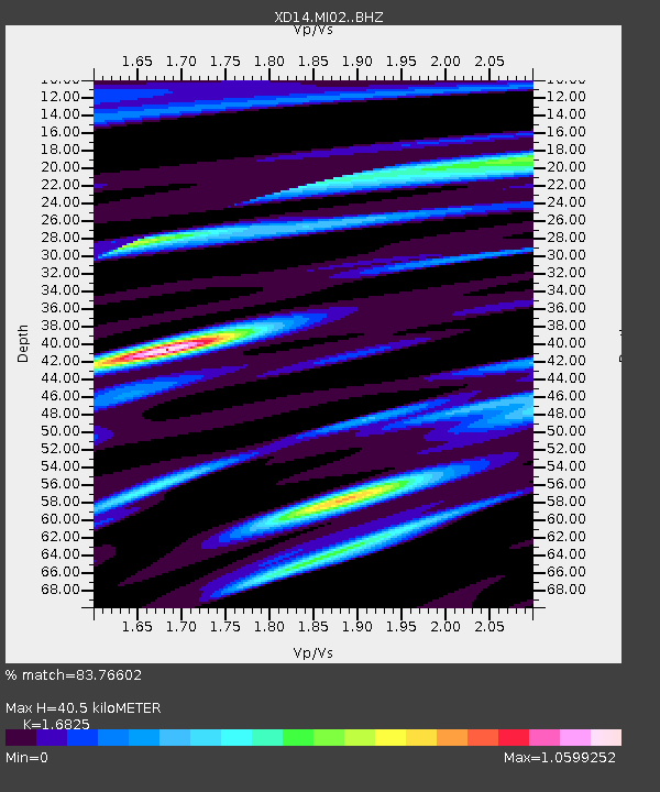
| Estimated Moho Depth: |
40.5 km |
| Estimated Crust Vp/Vs: |
1.68 |
| Assumed Crust Vp: |
6.566 km/s |
| Estimated Crust Vs: |
3.903 km/s |
| Estimated Crust Poisson's Ratio: |
0.23 |
|
| Radial Match: |
83.76602 % |
| Radial Bump: |
400 |
| Transverse Match: |
80.31711 % |
| Transverse Bump: |
400 |
| SOD ConfigId: |
7422571 |
| Insert Time: |
2019-04-22 14:46:34.672 +0000 |
| GWidth: |
2.5 |
| Max Bumps: |
400 |
| Tol: |
0.001 |
|

Signal To Noise
| Channel | StoN | STA | LTA |
| XD:MI02: :BHZ:20160518T08:06:30.79001Z | 10.014147 | 1.1065788E-6 | 1.1050156E-7 |
| XD:MI02: :BHN:20160518T08:06:30.79001Z | 2.3016129 | 3.7525558E-7 | 1.6304027E-7 |
| XD:MI02: :BHE:20160518T08:06:30.79001Z | 5.1935687 | 4.1625339E-7 | 8.0147856E-8 |
| Arrivals |
| Ps | 4.4 SECOND |
| PpPs | 16 SECOND |
| PsPs/PpSs | 20 SECOND |


