You are here: Home > Network List > XD14 - Illuminating the architecture of the greater Mount St. Helens magmatic systems f Stations List
> Station MJ07 "Mount St Helens, WA" > Earthquake Result Viewer
MJ07 "Mount St Helens, WA" - Earthquake Result Viewer
| Earthquake location: |
Near Coast Of Ecuador |
| Earthquake latitude/longitude: |
0.4/-79.8 |
| Earthquake time(UTC): |
2016/05/18 (139) 07:57:05 GMT |
| Earthquake Depth: |
32 km |
| Earthquake Magnitude: |
6.7 MWP, 6.7 MWW, 6.7 MI |
| Earthquake Catalog/Contributor: |
NEIC PDE/NEIC COMCAT |
|
| Network: |
XD Illuminating the architecture of the greater Mount St. Helens magmatic systems f |
| Station: |
MJ07 "Mount St Helens, WA" |
| Lat/Lon: |
46.18 N/122.06 W |
| Elevation: |
509 m |
|
| Distance: |
58.7 deg |
| Az: |
326.831 deg |
| Baz: |
128.059 deg |
| Ray Param: |
0.06260913 |
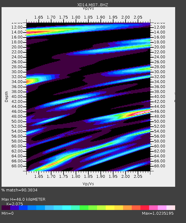
| Estimated Moho Depth: |
46.0 km |
| Estimated Crust Vp/Vs: |
2.08 |
| Assumed Crust Vp: |
6.566 km/s |
| Estimated Crust Vs: |
3.164 km/s |
| Estimated Crust Poisson's Ratio: |
0.35 |
|
| Radial Match: |
90.3834 % |
| Radial Bump: |
400 |
| Transverse Match: |
84.06844 % |
| Transverse Bump: |
400 |
| SOD ConfigId: |
7422571 |
| Insert Time: |
2019-04-22 14:46:42.390 +0000 |
| GWidth: |
2.5 |
| Max Bumps: |
400 |
| Tol: |
0.001 |
|

Signal To Noise
| Channel | StoN | STA | LTA |
| XD:MJ07: :BHZ:20160518T08:06:28.310029Z | 8.014512 | 8.776992E-7 | 1.0951375E-7 |
| XD:MJ07: :BHN:20160518T08:06:28.310029Z | 3.150885 | 2.3251373E-7 | 7.3793146E-8 |
| XD:MJ07: :BHE:20160518T08:06:28.310029Z | 2.377431 | 2.679997E-7 | 1.127266E-7 |
| Arrivals |
| Ps | 7.9 SECOND |
| PpPs | 21 SECOND |
| PsPs/PpSs | 28 SECOND |


