You are here: Home > Network List > US - United States National Seismic Network Stations List
> Station SDCO Great Sand Dunes National Park, Colorado, USA > Earthquake Result Viewer
SDCO Great Sand Dunes National Park, Colorado, USA - Earthquake Result Viewer
| Earthquake location: |
East Of Kuril Islands |
| Earthquake latitude/longitude: |
46.9/155.2 |
| Earthquake time(UTC): |
2009/01/15 (015) 17:49:39 GMT |
| Earthquake Depth: |
36 km |
| Earthquake Magnitude: |
6.9 MB, 7.5 MS, 7.4 MW, 7.4 MW |
| Earthquake Catalog/Contributor: |
WHDF/NEIC |
|
| Network: |
US United States National Seismic Network |
| Station: |
SDCO Great Sand Dunes National Park, Colorado, USA |
| Lat/Lon: |
37.75 N/105.50 W |
| Elevation: |
2569 m |
|
| Distance: |
69.2 deg |
| Az: |
56.795 deg |
| Baz: |
313.585 deg |
| Ray Param: |
0.055744335 |
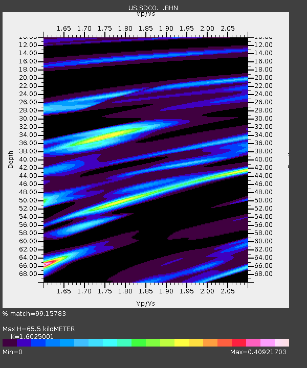
| Estimated Moho Depth: |
65.5 km |
| Estimated Crust Vp/Vs: |
1.60 |
| Assumed Crust Vp: |
6.316 km/s |
| Estimated Crust Vs: |
3.941 km/s |
| Estimated Crust Poisson's Ratio: |
0.18 |
|
| Radial Match: |
99.15783 % |
| Radial Bump: |
163 |
| Transverse Match: |
97.882126 % |
| Transverse Bump: |
346 |
| SOD ConfigId: |
2834 |
| Insert Time: |
2010-03-05 03:13:54.190 +0000 |
| GWidth: |
2.5 |
| Max Bumps: |
400 |
| Tol: |
0.001 |
|

Signal To Noise
| Channel | StoN | STA | LTA |
| US:SDCO: :BHN:20090115T18:00:11.247002Z | 40.523014 | 1.1304098E-5 | 2.78955E-7 |
| US:SDCO: :BHE:20090115T18:00:11.247002Z | 13.203488 | 1.982442E-6 | 1.5014533E-7 |
| US:SDCO: :BHZ:20090115T18:00:11.247002Z | 10.586033 | 3.8401695E-6 | 3.6275813E-7 |
| Arrivals |
| Ps | 6.5 SECOND |
| PpPs | 26 SECOND |
| PsPs/PpSs | 32 SECOND |


