You are here: Home > Network List > YT07 - POLENET Stations List
> Station HOWD HOWD > Earthquake Result Viewer
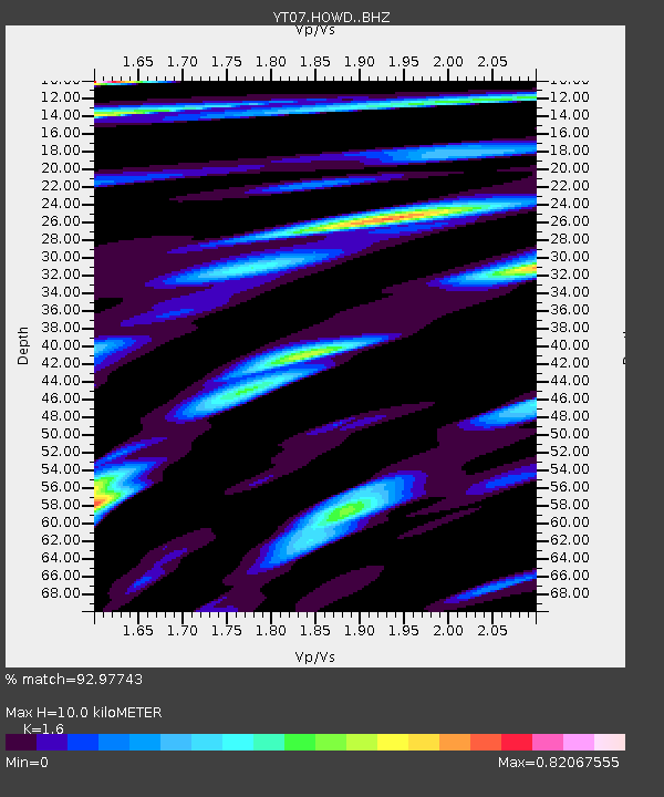
HOWD HOWD - Earthquake Result Viewer
| Earthquake location: |
Near Coast Of Ecuador |
| Earthquake latitude/longitude: |
0.4/-79.8 |
| Earthquake time(UTC): |
2016/05/18 (139) 07:57:05 GMT |
| Earthquake Depth: |
32 km |
| Earthquake Magnitude: |
6.7 MWP, 6.7 MWW, 6.7 MI |
| Earthquake Catalog/Contributor: |
NEIC PDE/NEIC COMCAT |
|
| Network: |
YT POLENET |
| Station: |
HOWD HOWD |
| Lat/Lon: |
77.53 S/86.77 W |
| Elevation: |
1495 m |
|
| Distance: |
78.0 deg |
| Az: |
181.553 deg |
| Baz: |
7.162 deg |
| Ray Param: |
0.04991704 |
| Estimated Moho Depth: |
10.0 km |
| Estimated Crust Vp/Vs: |
1.60 |
| Assumed Crust Vp: |
6.047 km/s |
| Estimated Crust Vs: |
3.779 km/s |
| Estimated Crust Poisson's Ratio: |
0.18 |
|
| Radial Match: |
92.97743 % |
| Radial Bump: |
400 |
| Transverse Match: |
84.52825 % |
| Transverse Bump: |
400 |
| SOD ConfigId: |
7422571 |
| Insert Time: |
2019-04-22 14:47:48.058 +0000 |
| GWidth: |
2.5 |
| Max Bumps: |
400 |
| Tol: |
0.001 |
|

Signal To Noise
| Channel | StoN | STA | LTA |
| YT:HOWD: :BHZ:20160518T08:08:28.59897Z | 23.37964 | 2.2754416E-6 | 9.7325774E-8 |
| YT:HOWD: :BHN:20160518T08:08:28.59897Z | 8.342222 | 8.928005E-7 | 1.07021904E-7 |
| YT:HOWD: :BHE:20160518T08:08:28.59897Z | 2.0379581 | 2.8512193E-7 | 1.399057E-7 |
| Arrivals |
| Ps | 1.0 SECOND |
| PpPs | 4.2 SECOND |
| PsPs/PpSs | 5.2 SECOND |


