You are here: Home > Network List > YT07 - POLENET Stations List
> Station SILY SILY > Earthquake Result Viewer
SILY SILY - Earthquake Result Viewer
| Earthquake location: |
Near Coast Of Ecuador |
| Earthquake latitude/longitude: |
0.4/-79.8 |
| Earthquake time(UTC): |
2016/05/18 (139) 07:57:05 GMT |
| Earthquake Depth: |
32 km |
| Earthquake Magnitude: |
6.7 MWP, 6.7 MWW, 6.7 MI |
| Earthquake Catalog/Contributor: |
NEIC PDE/NEIC COMCAT |
|
| Network: |
YT POLENET |
| Station: |
SILY SILY |
| Lat/Lon: |
77.13 S/125.97 W |
| Elevation: |
2093 m |
|
| Distance: |
81.5 deg |
| Az: |
189.413 deg |
| Baz: |
46.868 deg |
| Ray Param: |
0.047501866 |
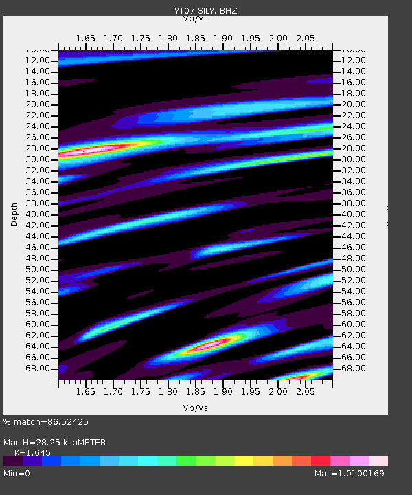
| Estimated Moho Depth: |
28.25 km |
| Estimated Crust Vp/Vs: |
1.64 |
| Assumed Crust Vp: |
6.138 km/s |
| Estimated Crust Vs: |
3.731 km/s |
| Estimated Crust Poisson's Ratio: |
0.21 |
|
| Radial Match: |
86.52425 % |
| Radial Bump: |
400 |
| Transverse Match: |
81.969795 % |
| Transverse Bump: |
400 |
| SOD ConfigId: |
7422571 |
| Insert Time: |
2019-04-22 14:48:03.392 +0000 |
| GWidth: |
2.5 |
| Max Bumps: |
400 |
| Tol: |
0.001 |
|

Signal To Noise
| Channel | StoN | STA | LTA |
| YT:SILY: :BHZ:20160518T08:08:47.649995Z | 11.407347 | 1.5297652E-6 | 1.3410352E-7 |
| YT:SILY: :BHN:20160518T08:08:47.649995Z | 3.375532 | 3.246073E-7 | 9.616479E-8 |
| YT:SILY: :BHE:20160518T08:08:47.649995Z | 5.9295006 | 5.222696E-7 | 8.8079865E-8 |
| Arrivals |
| Ps | 3.0 SECOND |
| PpPs | 12 SECOND |
| PsPs/PpSs | 15 SECOND |


