You are here: Home > Network List > 7A - Mid-Atlantic Geophysical Integrative Collaboration Stations List
> Station ALMA Alma, West Virginia USA > Earthquake Result Viewer
ALMA Alma, West Virginia USA - Earthquake Result Viewer
| Earthquake location: |
Near Coast Of Ecuador |
| Earthquake latitude/longitude: |
0.5/-79.6 |
| Earthquake time(UTC): |
2016/05/18 (139) 16:46:44 GMT |
| Earthquake Depth: |
31 km |
| Earthquake Magnitude: |
6.8 MO |
| Earthquake Catalog/Contributor: |
NEIC PDE/NEIC ALERT |
|
| Network: |
7A Mid-Atlantic Geophysical Integrative Collaboration |
| Station: |
ALMA Alma, West Virginia USA |
| Lat/Lon: |
39.40 N/80.84 W |
| Elevation: |
233 m |
|
| Distance: |
38.8 deg |
| Az: |
358.52 deg |
| Baz: |
178.09 deg |
| Ray Param: |
0.07531259 |
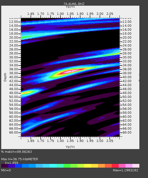
| Estimated Moho Depth: |
36.75 km |
| Estimated Crust Vp/Vs: |
1.86 |
| Assumed Crust Vp: |
6.207 km/s |
| Estimated Crust Vs: |
3.346 km/s |
| Estimated Crust Poisson's Ratio: |
0.30 |
|
| Radial Match: |
89.86263 % |
| Radial Bump: |
280 |
| Transverse Match: |
59.642242 % |
| Transverse Bump: |
400 |
| SOD ConfigId: |
7422571 |
| Insert Time: |
2019-04-22 14:49:05.998 +0000 |
| GWidth: |
2.5 |
| Max Bumps: |
400 |
| Tol: |
0.001 |
|

Signal To Noise
| Channel | StoN | STA | LTA |
| 7A:ALMA: :BHZ:20160518T16:53:34.829987Z | 8.17467 | 2.328513E-6 | 2.8484487E-7 |
| 7A:ALMA: :BHN:20160518T16:53:34.829987Z | 7.6561956 | 1.5884813E-6 | 2.0747657E-7 |
| 7A:ALMA: :BHE:20160518T16:53:34.829987Z | 1.4175187 | 3.2434073E-7 | 2.2880877E-7 |
| Arrivals |
| Ps | 5.4 SECOND |
| PpPs | 16 SECOND |
| PsPs/PpSs | 21 SECOND |


