You are here: Home > Network List > 7A - Mid-Atlantic Geophysical Integrative Collaboration Stations List
> Station CABN Riverton, West Virginia USA > Earthquake Result Viewer
CABN Riverton, West Virginia USA - Earthquake Result Viewer
| Earthquake location: |
Near Coast Of Ecuador |
| Earthquake latitude/longitude: |
0.5/-79.6 |
| Earthquake time(UTC): |
2016/05/18 (139) 16:46:44 GMT |
| Earthquake Depth: |
31 km |
| Earthquake Magnitude: |
6.8 MO |
| Earthquake Catalog/Contributor: |
NEIC PDE/NEIC ALERT |
|
| Network: |
7A Mid-Atlantic Geophysical Integrative Collaboration |
| Station: |
CABN Riverton, West Virginia USA |
| Lat/Lon: |
38.72 N/79.44 W |
| Elevation: |
910 m |
|
| Distance: |
38.1 deg |
| Az: |
0.253 deg |
| Baz: |
180.323 deg |
| Ray Param: |
0.07571591 |
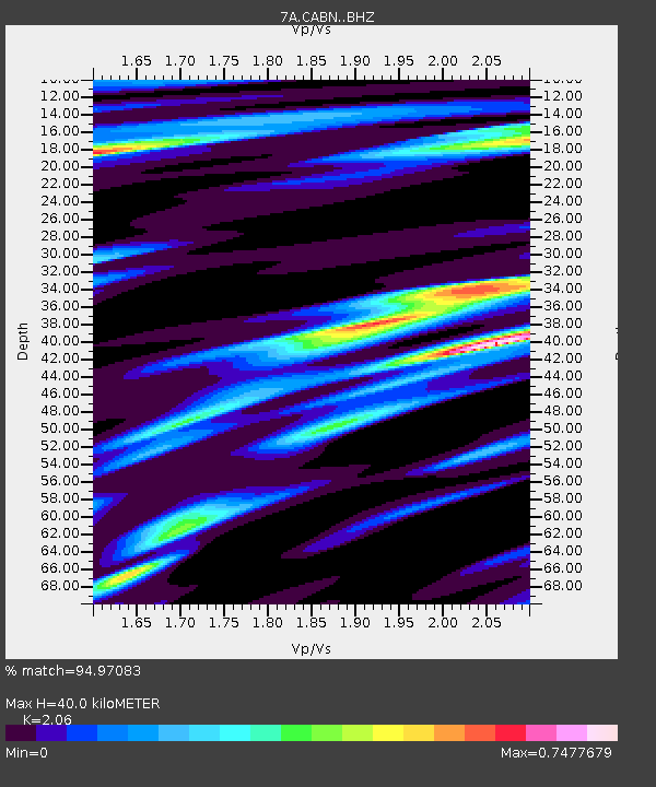
| Estimated Moho Depth: |
40.0 km |
| Estimated Crust Vp/Vs: |
2.06 |
| Assumed Crust Vp: |
6.159 km/s |
| Estimated Crust Vs: |
2.99 km/s |
| Estimated Crust Poisson's Ratio: |
0.35 |
|
| Radial Match: |
94.97083 % |
| Radial Bump: |
356 |
| Transverse Match: |
85.042206 % |
| Transverse Bump: |
400 |
| SOD ConfigId: |
7422571 |
| Insert Time: |
2019-04-22 14:49:07.146 +0000 |
| GWidth: |
2.5 |
| Max Bumps: |
400 |
| Tol: |
0.001 |
|

Signal To Noise
| Channel | StoN | STA | LTA |
| 7A:CABN: :BHZ:20160518T16:53:28.959991Z | 22.071976 | 2.7139542E-6 | 1.2295929E-7 |
| 7A:CABN: :BHN:20160518T16:53:28.959991Z | 13.1935625 | 1.8016593E-6 | 1.3655594E-7 |
| 7A:CABN: :BHE:20160518T16:53:28.959991Z | 3.0413914 | 4.583865E-7 | 1.5071605E-7 |
| Arrivals |
| Ps | 7.3 SECOND |
| PpPs | 19 SECOND |
| PsPs/PpSs | 26 SECOND |


