You are here: Home > Network List > 7A - Mid-Atlantic Geophysical Integrative Collaboration Stations List
> Station PAUL Paulding, Ohio USA > Earthquake Result Viewer
PAUL Paulding, Ohio USA - Earthquake Result Viewer
| Earthquake location: |
Near Coast Of Ecuador |
| Earthquake latitude/longitude: |
0.5/-79.6 |
| Earthquake time(UTC): |
2016/05/18 (139) 16:46:44 GMT |
| Earthquake Depth: |
31 km |
| Earthquake Magnitude: |
6.8 MO |
| Earthquake Catalog/Contributor: |
NEIC PDE/NEIC ALERT |
|
| Network: |
7A Mid-Atlantic Geophysical Integrative Collaboration |
| Station: |
PAUL Paulding, Ohio USA |
| Lat/Lon: |
41.14 N/84.55 W |
| Elevation: |
0.0 m |
|
| Distance: |
40.7 deg |
| Az: |
354.317 deg |
| Baz: |
172.467 deg |
| Ray Param: |
0.0741718 |
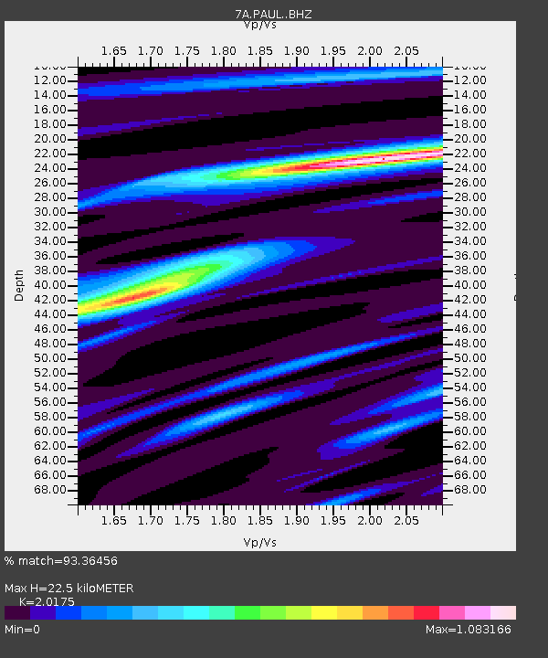
| Estimated Moho Depth: |
22.5 km |
| Estimated Crust Vp/Vs: |
2.02 |
| Assumed Crust Vp: |
6.498 km/s |
| Estimated Crust Vs: |
3.221 km/s |
| Estimated Crust Poisson's Ratio: |
0.34 |
|
| Radial Match: |
93.36456 % |
| Radial Bump: |
329 |
| Transverse Match: |
68.77509 % |
| Transverse Bump: |
400 |
| SOD ConfigId: |
7422571 |
| Insert Time: |
2019-04-22 14:49:17.592 +0000 |
| GWidth: |
2.5 |
| Max Bumps: |
400 |
| Tol: |
0.001 |
|

Signal To Noise
| Channel | StoN | STA | LTA |
| 7A:PAUL: :BHZ:20160518T16:53:51.089996Z | 17.03171 | 2.6356036E-6 | 1.5474687E-7 |
| 7A:PAUL: :BHN:20160518T16:53:51.089996Z | 7.1098447 | 1.4376872E-6 | 2.0221076E-7 |
| 7A:PAUL: :BHE:20160518T16:53:51.089996Z | 1.0745331 | 2.1675538E-7 | 2.0172054E-7 |
| Arrivals |
| Ps | 3.7 SECOND |
| PpPs | 9.8 SECOND |
| PsPs/PpSs | 14 SECOND |


