You are here: Home > Network List > 7A - Mid-Atlantic Geophysical Integrative Collaboration Stations List
> Station PETO Lost Creek, West Virginia USA > Earthquake Result Viewer
PETO Lost Creek, West Virginia USA - Earthquake Result Viewer
| Earthquake location: |
Near Coast Of Ecuador |
| Earthquake latitude/longitude: |
0.5/-79.6 |
| Earthquake time(UTC): |
2016/05/18 (139) 16:46:44 GMT |
| Earthquake Depth: |
31 km |
| Earthquake Magnitude: |
6.8 MO |
| Earthquake Catalog/Contributor: |
NEIC PDE/NEIC ALERT |
|
| Network: |
7A Mid-Atlantic Geophysical Integrative Collaboration |
| Station: |
PETO Lost Creek, West Virginia USA |
| Lat/Lon: |
39.16 N/80.33 W |
| Elevation: |
0.0 m |
|
| Distance: |
38.5 deg |
| Az: |
359.14 deg |
| Baz: |
178.894 deg |
| Ray Param: |
0.07545947 |
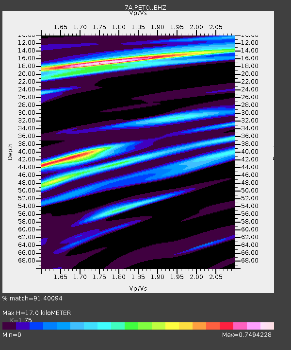
| Estimated Moho Depth: |
17.0 km |
| Estimated Crust Vp/Vs: |
1.75 |
| Assumed Crust Vp: |
6.207 km/s |
| Estimated Crust Vs: |
3.547 km/s |
| Estimated Crust Poisson's Ratio: |
0.26 |
|
| Radial Match: |
91.40094 % |
| Radial Bump: |
400 |
| Transverse Match: |
69.56359 % |
| Transverse Bump: |
400 |
| SOD ConfigId: |
7422571 |
| Insert Time: |
2019-04-22 14:49:19.810 +0000 |
| GWidth: |
2.5 |
| Max Bumps: |
400 |
| Tol: |
0.001 |
|

Signal To Noise
| Channel | StoN | STA | LTA |
| 7A:PETO: :BHZ:20160518T16:53:32.690002Z | 8.907121 | 2.5354648E-6 | 2.8465593E-7 |
| 7A:PETO: :BHN:20160518T16:53:32.690002Z | 3.5062685 | 1.4259308E-6 | 4.0668044E-7 |
| 7A:PETO: :BHE:20160518T16:53:32.690002Z | 1.1079688 | 3.0062745E-7 | 2.7133206E-7 |
| Arrivals |
| Ps | 2.2 SECOND |
| PpPs | 7.0 SECOND |
| PsPs/PpSs | 9.2 SECOND |


