You are here: Home > Network List > AK - Alaska Regional Network Stations List
> Station CUT Chulitna, AK, USA > Earthquake Result Viewer
CUT Chulitna, AK, USA - Earthquake Result Viewer
| Earthquake location: |
Near Coast Of Ecuador |
| Earthquake latitude/longitude: |
0.5/-79.6 |
| Earthquake time(UTC): |
2016/05/18 (139) 16:46:44 GMT |
| Earthquake Depth: |
31 km |
| Earthquake Magnitude: |
6.8 MO |
| Earthquake Catalog/Contributor: |
NEIC PDE/NEIC ALERT |
|
| Network: |
AK Alaska Regional Network |
| Station: |
CUT Chulitna, AK, USA |
| Lat/Lon: |
62.41 N/150.26 W |
| Elevation: |
574 m |
|
| Distance: |
80.7 deg |
| Az: |
333.569 deg |
| Baz: |
107.081 deg |
| Ray Param: |
0.048059996 |
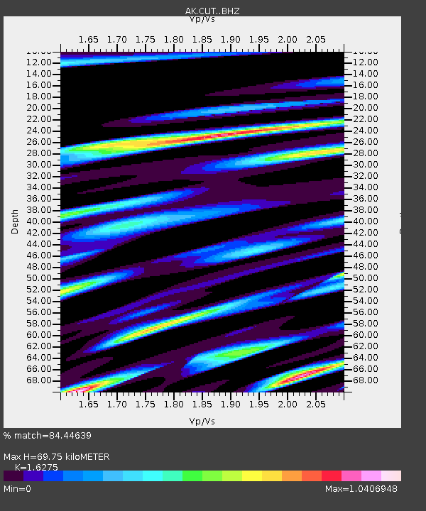
| Estimated Moho Depth: |
69.75 km |
| Estimated Crust Vp/Vs: |
1.63 |
| Assumed Crust Vp: |
6.438 km/s |
| Estimated Crust Vs: |
3.956 km/s |
| Estimated Crust Poisson's Ratio: |
0.20 |
|
| Radial Match: |
84.44639 % |
| Radial Bump: |
400 |
| Transverse Match: |
74.32002 % |
| Transverse Bump: |
307 |
| SOD ConfigId: |
7422571 |
| Insert Time: |
2019-04-22 14:49:54.500 +0000 |
| GWidth: |
2.5 |
| Max Bumps: |
400 |
| Tol: |
0.001 |
|

Signal To Noise
| Channel | StoN | STA | LTA |
| AK:CUT: :BHZ:20160518T16:58:22.780029Z | 11.22479 | 1.8882638E-6 | 1.6822264E-7 |
| AK:CUT: :BHN:20160518T16:58:22.780029Z | 2.6990733 | 7.038665E-7 | 2.607808E-7 |
| AK:CUT: :BHE:20160518T16:58:22.780029Z | 3.6016686 | 9.733201E-7 | 2.7024143E-7 |
| Arrivals |
| Ps | 7.0 SECOND |
| PpPs | 28 SECOND |
| PsPs/PpSs | 35 SECOND |


