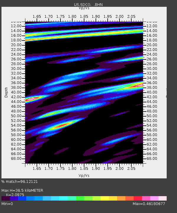
SDCO Great Sand Dunes National Park, Colorado, USA - Earthquake Result Viewer

Earthquake location: Andreanof Islands, Aleutian Is.
Earthquake latitude/longitude: 51.2/-179.3
Earthquake time(UTC): 2006/07/08 (189) 20:40:00 GMT
Earthquake Depth: 22 km
Earthquake Magnitude: 6.2 MB, 6.4 MS, 6.6 MW, 6.6 MW
Earthquake Catalog/Contributor: WHDF/NEIC
Network: US United States National Seismic Network
Station: SDCO Great Sand Dunes National Park, Colorado, USA
Lat/Lon: 37.75 N/105.50 W
Elevation: 2569 m
Distance: 52.2 deg
Az: 74.468 deg
Baz: 310.142 deg
Ray Param: 0.066882566
Estimated Moho Depth: 36.5 km
Estimated Crust Vp/Vs: 2.10
Assumed Crust Vp: 6.316 km/s
Estimated Crust Vs: 3.011 km/s
Estimated Crust Poisson's Ratio: 0.35
Radial Match: 96.12121 %
Radial Bump: 381
Transverse Match: 91.90228 %
Transverse Bump: 400
SOD ConfigId: 5423
Insert Time: 2010-03-05 03:14:51.825 +0000
GWidth: 2.5
Max Bumps: 400
Tol: 0.001

Signal To Noise

ChannelStoNSTALTA
US:SDCO: :BHN:20060708T20:48:39.156025Z2.23124071.8728143E-78.3936E-8
US:SDCO: :BHE:20060708T20:48:39.156025Z3.3012675.411564E-71.6392386E-7
US:SDCO: :BHZ:20060708T20:48:39.156025Z2.97587739.1780385E-73.0841454E-7
Arrivals
Ps6.6 SECOND
PpPs17 SECOND
PsPs/PpSs24 SECOND