You are here: Home > Network List > US - United States National Seismic Network Stations List
> Station SDCO Great Sand Dunes National Park, Colorado, USA > Earthquake Result Viewer
SDCO Great Sand Dunes National Park, Colorado, USA - Earthquake Result Viewer

| Earthquake location: |
Chile-Bolivia Border Region |
| Earthquake latitude/longitude: |
-21.3/-68.5 |
| Earthquake time(UTC): |
2006/06/27 (178) 11:24:36 GMT |
| Earthquake Depth: |
122 km |
| Earthquake Magnitude: |
5.2 MB, 5.5 MW |
| Earthquake Catalog/Contributor: |
WHDF/NEIC |
|
| Network: |
US United States National Seismic Network |
| Station: |
SDCO Great Sand Dunes National Park, Colorado, USA |
| Lat/Lon: |
37.75 N/105.50 W |
| Elevation: |
2569 m |
|
| Distance: |
68.3 deg |
| Az: |
329.106 deg |
| Baz: |
142.839 deg |
| Ray Param: |
0.056102227 |
| Estimated Moho Depth: |
10.0 km |
| Estimated Crust Vp/Vs: |
1.60 |
| Assumed Crust Vp: |
6.316 km/s |
| Estimated Crust Vs: |
3.947 km/s |
| Estimated Crust Poisson's Ratio: |
0.18 |
|
| Radial Match: |
99.93235 % |
| Radial Bump: |
5 |
| Transverse Match: |
99.95186 % |
| Transverse Bump: |
5 |
| SOD ConfigId: |
5423 |
| Insert Time: |
2010-03-05 03:14:55.411 +0000 |
| GWidth: |
2.5 |
| Max Bumps: |
400 |
| Tol: |
0.001 |
|
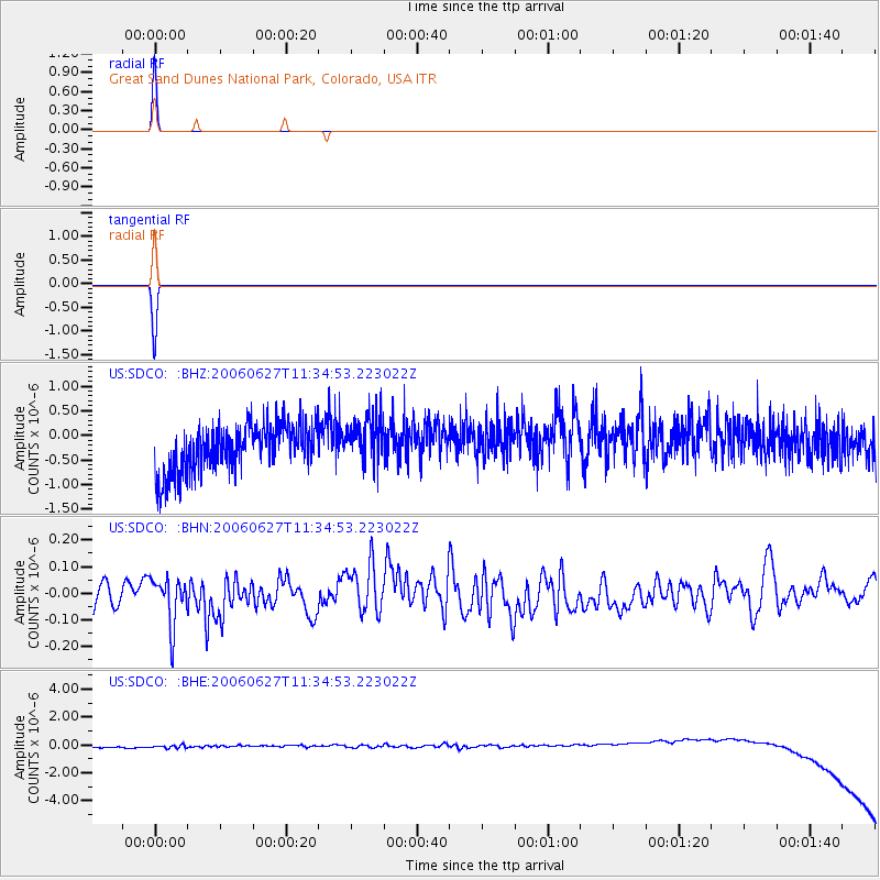
Signal To Noise
| Channel | StoN | STA | LTA |
| US:SDCO: :BHN:20060627T11:34:53.223022Z | 2.2202075 | 8.836253E-8 | 3.9799225E-8 |
| US:SDCO: :BHE:20060627T11:34:53.223022Z | 0.91464305 | 3.9492318E-7 | 4.317785E-7 |
| US:SDCO: :BHZ:20060627T11:34:53.223022Z | 1.0053947 | 4.7846527E-7 | 4.7589793E-7 |
| Arrivals |
| Ps | 1.0 SECOND |
| PpPs | 4.0 SECOND |
| PsPs/PpSs | 4.9 SECOND |


