You are here: Home > Network List > US - United States National Seismic Network Stations List
> Station SDCO Great Sand Dunes National Park, Colorado, USA > Earthquake Result Viewer
SDCO Great Sand Dunes National Park, Colorado, USA - Earthquake Result Viewer
| Earthquake location: |
Off Coast Of Northern Chile |
| Earthquake latitude/longitude: |
-18.1/-71.2 |
| Earthquake time(UTC): |
2006/05/25 (145) 20:48:05 GMT |
| Earthquake Depth: |
35 km |
| Earthquake Magnitude: |
5.5 MB, 5.1 MS, 5.6 MW, 5.5 MW |
| Earthquake Catalog/Contributor: |
WHDF/NEIC |
|
| Network: |
US United States National Seismic Network |
| Station: |
SDCO Great Sand Dunes National Park, Colorado, USA |
| Lat/Lon: |
37.75 N/105.50 W |
| Elevation: |
2569 m |
|
| Distance: |
64.3 deg |
| Az: |
330.244 deg |
| Baz: |
143.463 deg |
| Ray Param: |
0.058957998 |
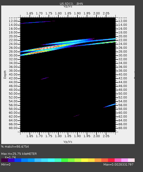
| Estimated Moho Depth: |
25.75 km |
| Estimated Crust Vp/Vs: |
1.74 |
| Assumed Crust Vp: |
6.316 km/s |
| Estimated Crust Vs: |
3.63 km/s |
| Estimated Crust Poisson's Ratio: |
0.25 |
|
| Radial Match: |
98.6754 % |
| Radial Bump: |
71 |
| Transverse Match: |
98.674515 % |
| Transverse Bump: |
73 |
| SOD ConfigId: |
2669 |
| Insert Time: |
2010-03-05 03:15:18.322 +0000 |
| GWidth: |
2.5 |
| Max Bumps: |
400 |
| Tol: |
0.001 |
|

Signal To Noise
| Channel | StoN | STA | LTA |
| US:SDCO: :BHN:20060525T20:58:06.488003Z | 0.96431 | 1.2411621E-7 | 1.2870987E-7 |
| US:SDCO: :BHE:20060525T20:58:06.488003Z | 1.1592101 | 3.1977962E-7 | 2.7585992E-7 |
| US:SDCO: :BHZ:20060525T20:58:06.488003Z | 1.4145561 | 4.996721E-7 | 3.5323598E-7 |
| Arrivals |
| Ps | 3.1 SECOND |
| PpPs | 11 SECOND |
| PsPs/PpSs | 14 SECOND |


