You are here: Home > Network List > US - United States National Seismic Network Stations List
> Station SDCO Great Sand Dunes National Park, Colorado, USA > Earthquake Result Viewer
SDCO Great Sand Dunes National Park, Colorado, USA - Earthquake Result Viewer
| Earthquake location: |
Off Coast Of Ecuador |
| Earthquake latitude/longitude: |
1.5/-85.3 |
| Earthquake time(UTC): |
2006/05/21 (141) 02:07:36 GMT |
| Earthquake Depth: |
10 km |
| Earthquake Magnitude: |
5.3 MB, 5.7 MS, 6.0 MW, 5.9 MW |
| Earthquake Catalog/Contributor: |
WHDF/NEIC |
|
| Network: |
US United States National Seismic Network |
| Station: |
SDCO Great Sand Dunes National Park, Colorado, USA |
| Lat/Lon: |
37.75 N/105.50 W |
| Elevation: |
2569 m |
|
| Distance: |
40.5 deg |
| Az: |
335.098 deg |
| Baz: |
147.929 deg |
| Ray Param: |
0.07435105 |
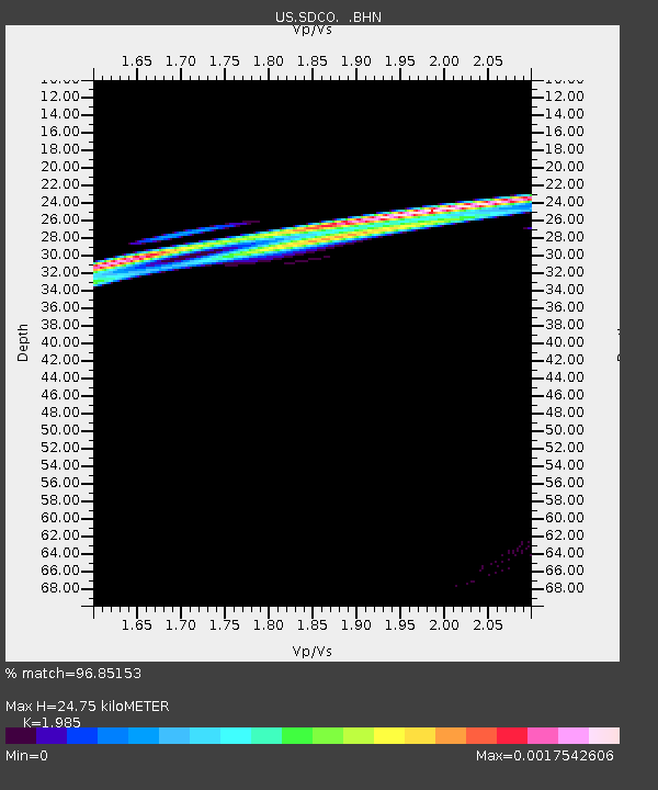
| Estimated Moho Depth: |
24.75 km |
| Estimated Crust Vp/Vs: |
1.99 |
| Assumed Crust Vp: |
6.316 km/s |
| Estimated Crust Vs: |
3.182 km/s |
| Estimated Crust Poisson's Ratio: |
0.33 |
|
| Radial Match: |
96.85153 % |
| Radial Bump: |
70 |
| Transverse Match: |
98.185356 % |
| Transverse Bump: |
49 |
| SOD ConfigId: |
2669 |
| Insert Time: |
2010-03-05 03:15:20.775 +0000 |
| GWidth: |
2.5 |
| Max Bumps: |
400 |
| Tol: |
0.001 |
|

Signal To Noise
| Channel | StoN | STA | LTA |
| US:SDCO: :BHN:20060521T02:14:44.738014Z | 0.75468016 | 7.771416E-8 | 1.0297629E-7 |
| US:SDCO: :BHE:20060521T02:14:44.738014Z | 0.50248295 | 1.0393939E-7 | 2.0685158E-7 |
| US:SDCO: :BHZ:20060521T02:14:44.738014Z | 1.5031302 | 4.536616E-7 | 3.0181127E-7 |
| Arrivals |
| Ps | 4.1 SECOND |
| PpPs | 11 SECOND |
| PsPs/PpSs | 15 SECOND |


