You are here: Home > Network List > US - United States National Seismic Network Stations List
> Station SDCO Great Sand Dunes National Park, Colorado, USA > Earthquake Result Viewer
SDCO Great Sand Dunes National Park, Colorado, USA - Earthquake Result Viewer
| Earthquake location: |
Central Mid-Atlantic Ridge |
| Earthquake latitude/longitude: |
1.0/-28.2 |
| Earthquake time(UTC): |
2006/06/05 (156) 06:34:31 GMT |
| Earthquake Depth: |
10 km |
| Earthquake Magnitude: |
5.3 MB, 5.6 MW |
| Earthquake Catalog/Contributor: |
WHDF/NEIC |
|
| Network: |
US United States National Seismic Network |
| Station: |
SDCO Great Sand Dunes National Park, Colorado, USA |
| Lat/Lon: |
37.75 N/105.50 W |
| Elevation: |
2569 m |
|
| Distance: |
79.4 deg |
| Az: |
308.098 deg |
| Baz: |
96.989 deg |
| Ray Param: |
0.049007915 |
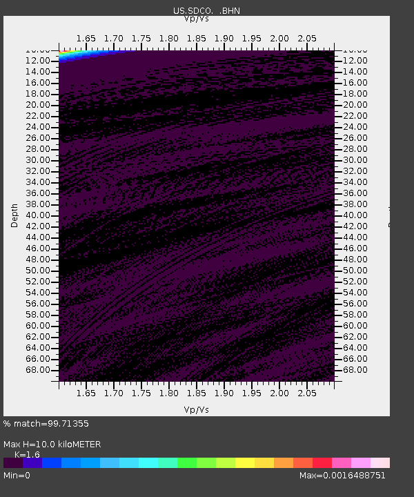
| Estimated Moho Depth: |
10.0 km |
| Estimated Crust Vp/Vs: |
1.60 |
| Assumed Crust Vp: |
6.316 km/s |
| Estimated Crust Vs: |
3.947 km/s |
| Estimated Crust Poisson's Ratio: |
0.18 |
|
| Radial Match: |
99.71355 % |
| Radial Bump: |
26 |
| Transverse Match: |
98.53929 % |
| Transverse Bump: |
61 |
| SOD ConfigId: |
2669 |
| Insert Time: |
2010-03-05 03:15:22.651 +0000 |
| GWidth: |
2.5 |
| Max Bumps: |
400 |
| Tol: |
0.001 |
|
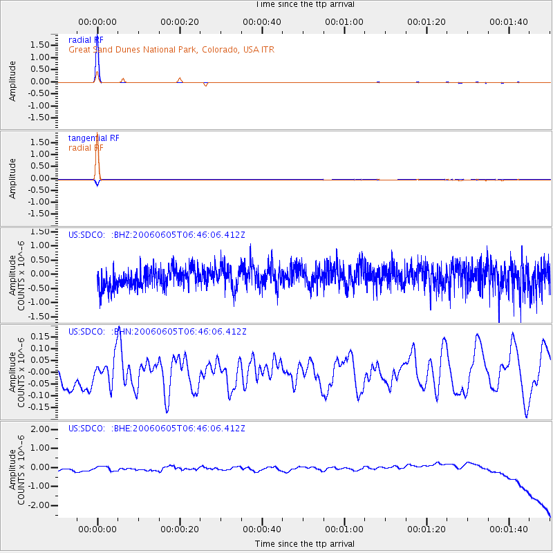
Signal To Noise
| Channel | StoN | STA | LTA |
| US:SDCO: :BHN:20060605T06:46:06.412Z | 0.66820157 | 5.7015118E-8 | 8.532623E-8 |
| US:SDCO: :BHE:20060605T06:46:06.412Z | 0.8542054 | 1.671339E-7 | 1.9566009E-7 |
| US:SDCO: :BHZ:20060605T06:46:06.412Z | 1.2156813 | 3.9120135E-7 | 3.21796E-7 |
| Arrivals |
| Ps | 1.0 SECOND |
| PpPs | 4.0 SECOND |
| PsPs/PpSs | 5.0 SECOND |


