You are here: Home > Network List > US - United States National Seismic Network Stations List
> Station SDCO Great Sand Dunes National Park, Colorado, USA > Earthquake Result Viewer
SDCO Great Sand Dunes National Park, Colorado, USA - Earthquake Result Viewer
| Earthquake location: |
Panama-Costa Rica Border Region |
| Earthquake latitude/longitude: |
8.2/-82.9 |
| Earthquake time(UTC): |
2006/05/01 (121) 07:47:59 GMT |
| Earthquake Depth: |
13 km |
| Earthquake Magnitude: |
5.1 MB, 5.6 MS, 5.9 MW, 5.9 MW |
| Earthquake Catalog/Contributor: |
WHDF/NEIC |
|
| Network: |
US United States National Seismic Network |
| Station: |
SDCO Great Sand Dunes National Park, Colorado, USA |
| Lat/Lon: |
37.75 N/105.50 W |
| Elevation: |
2569 m |
|
| Distance: |
35.9 deg |
| Az: |
328.639 deg |
| Baz: |
139.463 deg |
| Ray Param: |
0.07698722 |
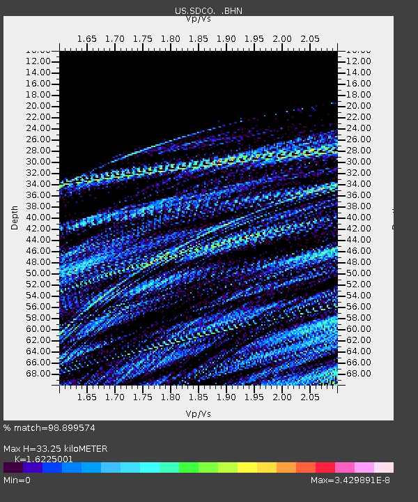
| Estimated Moho Depth: |
33.25 km |
| Estimated Crust Vp/Vs: |
1.62 |
| Assumed Crust Vp: |
6.316 km/s |
| Estimated Crust Vs: |
3.892 km/s |
| Estimated Crust Poisson's Ratio: |
0.19 |
|
| Radial Match: |
98.899574 % |
| Radial Bump: |
34 |
| Transverse Match: |
99.392006 % |
| Transverse Bump: |
23 |
| SOD ConfigId: |
2669 |
| Insert Time: |
2010-03-05 03:15:24.751 +0000 |
| GWidth: |
2.5 |
| Max Bumps: |
400 |
| Tol: |
0.001 |
|
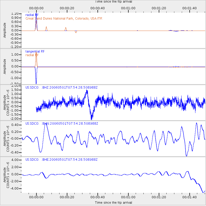
Signal To Noise
| Channel | StoN | STA | LTA |
| US:SDCO: :BHN:20060501T07:54:28.508988Z | 3.9975138 | 2.2351426E-7 | 5.591332E-8 |
| US:SDCO: :BHE:20060501T07:54:28.508988Z | 0.7141404 | 2.6977938E-7 | 3.7776798E-7 |
| US:SDCO: :BHZ:20060501T07:54:28.508988Z | 2.1345088 | 8.3846055E-7 | 3.928119E-7 |
| Arrivals |
| Ps | 3.5 SECOND |
| PpPs | 13 SECOND |
| PsPs/PpSs | 16 SECOND |


