You are here: Home > Network List > C1 - Red Sismologica Nacional Stations List
> Station LL03 Petrohue > Earthquake Result Viewer
LL03 Petrohue - Earthquake Result Viewer
| Earthquake location: |
Near Coast Of Ecuador |
| Earthquake latitude/longitude: |
0.5/-79.6 |
| Earthquake time(UTC): |
2016/05/18 (139) 16:46:44 GMT |
| Earthquake Depth: |
31 km |
| Earthquake Magnitude: |
6.8 MO |
| Earthquake Catalog/Contributor: |
NEIC PDE/NEIC ALERT |
|
| Network: |
C1 Red Sismologica Nacional |
| Station: |
LL03 Petrohue |
| Lat/Lon: |
41.14 S/72.40 W |
| Elevation: |
227 m |
|
| Distance: |
41.9 deg |
| Az: |
171.813 deg |
| Baz: |
349.133 deg |
| Ray Param: |
0.07341826 |
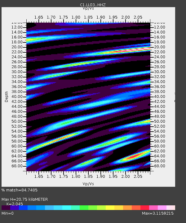
| Estimated Moho Depth: |
20.75 km |
| Estimated Crust Vp/Vs: |
2.05 |
| Assumed Crust Vp: |
6.522 km/s |
| Estimated Crust Vs: |
3.189 km/s |
| Estimated Crust Poisson's Ratio: |
0.34 |
|
| Radial Match: |
84.7485 % |
| Radial Bump: |
400 |
| Transverse Match: |
72.925385 % |
| Transverse Bump: |
400 |
| SOD ConfigId: |
7422571 |
| Insert Time: |
2019-04-22 14:51:53.721 +0000 |
| GWidth: |
2.5 |
| Max Bumps: |
400 |
| Tol: |
0.001 |
|

Signal To Noise
| Channel | StoN | STA | LTA |
| C1:LL03: :HHZ:20160518T16:54:01.368988Z | 14.667457 | 2.9933094E-6 | 2.0407829E-7 |
| C1:LL03: :HHN:20160518T16:54:01.368988Z | 12.464604 | 3.2590315E-6 | 2.614629E-7 |
| C1:LL03: :HHE:20160518T16:54:01.368988Z | 4.0027456 | 8.2198613E-7 | 2.0535558E-7 |
| Arrivals |
| Ps | 3.5 SECOND |
| PpPs | 9.1 SECOND |
| PsPs/PpSs | 13 SECOND |


