You are here: Home > Network List > US - United States National Seismic Network Stations List
> Station SDCO Great Sand Dunes National Park, Colorado, USA > Earthquake Result Viewer
SDCO Great Sand Dunes National Park, Colorado, USA - Earthquake Result Viewer
| Earthquake location: |
Near Coast Of Northern Chile |
| Earthquake latitude/longitude: |
-27.3/-71.2 |
| Earthquake time(UTC): |
2006/04/30 (120) 20:12:19 GMT |
| Earthquake Depth: |
20 km |
| Earthquake Magnitude: |
5.2 MB, 5.6 ML |
| Earthquake Catalog/Contributor: |
WHDF/NEIC |
|
| Network: |
US United States National Seismic Network |
| Station: |
SDCO Great Sand Dunes National Park, Colorado, USA |
| Lat/Lon: |
37.75 N/105.50 W |
| Elevation: |
2569 m |
|
| Distance: |
72.2 deg |
| Az: |
332.05 deg |
| Baz: |
148.248 deg |
| Ray Param: |
0.05377996 |
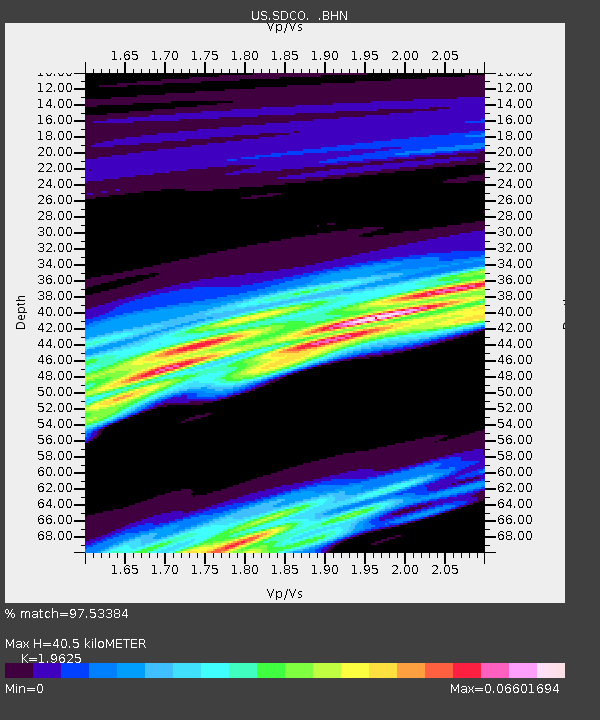
| Estimated Moho Depth: |
40.5 km |
| Estimated Crust Vp/Vs: |
1.96 |
| Assumed Crust Vp: |
6.316 km/s |
| Estimated Crust Vs: |
3.218 km/s |
| Estimated Crust Poisson's Ratio: |
0.32 |
|
| Radial Match: |
97.53384 % |
| Radial Bump: |
134 |
| Transverse Match: |
98.74305 % |
| Transverse Bump: |
117 |
| SOD ConfigId: |
2669 |
| Insert Time: |
2010-03-05 03:15:27.930 +0000 |
| GWidth: |
2.5 |
| Max Bumps: |
400 |
| Tol: |
0.001 |
|

Signal To Noise
| Channel | StoN | STA | LTA |
| US:SDCO: :BHN:20060430T20:23:11.434021Z | 1.5109607 | 1.1969447E-6 | 7.921746E-7 |
| US:SDCO: :BHE:20060430T20:23:11.434021Z | 0.8105009 | 7.157936E-7 | 8.8314965E-7 |
| US:SDCO: :BHZ:20060430T20:23:11.434021Z | 0.98183894 | 7.045134E-7 | 7.1754476E-7 |
| Arrivals |
| Ps | 6.4 SECOND |
| PpPs | 18 SECOND |
| PsPs/PpSs | 25 SECOND |


