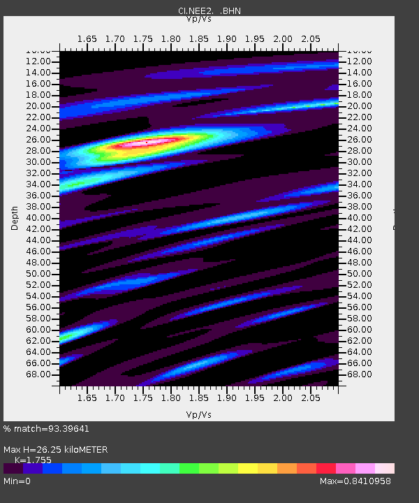
NEE2 Needles Airport - Earthquake Result Viewer
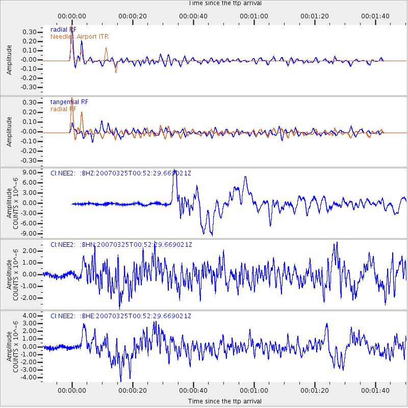
Earthquake location: Vanuatu Islands
Earthquake latitude/longitude: -20.6/169.4
Earthquake time(UTC): 2007/03/25 (084) 00:40:01 GMT
Earthquake Depth: 34 km
Earthquake Magnitude: 6.5 MB, 7.0 MS, 7.1 MW, 7.1 MW
Earthquake Catalog/Contributor: WHDF/NEIC
Network: CI Caltech Regional Seismic Network
Station: NEE2 Needles Airport
Lat/Lon: 34.77 N/114.62 W
Elevation: 271 m
Distance: 90.7 deg
Az: 53.03 deg
Baz: 245.377 deg
Ray Param: 0.041649524
Estimated Moho Depth: 26.25 km
Estimated Crust Vp/Vs: 1.75
Assumed Crust Vp: 6.276 km/s
Estimated Crust Vs: 3.576 km/s
Estimated Crust Poisson's Ratio: 0.26
Radial Match: 93.39641 %
Radial Bump: 400
Transverse Match: 77.5438 %
Transverse Bump: 400
SOD ConfigId: 2564
Insert Time: 2010-02-26 00:22:54.764 +0000
GWidth: 2.5
Max Bumps: 400
Tol: 0.001

Signal To Noise

ChannelStoNSTALTA
CI:NEE2: :BHN:20070325T00:52:29.669021Z4.584596.107667E-71.3322166E-7
CI:NEE2: :BHE:20070325T00:52:29.669021Z6.97322231.2351094E-61.7712176E-7
CI:NEE2: :BHZ:20070325T00:52:29.669021Z19.9321584.4175017E-62.2162686E-7
Arrivals
Ps3.2 SECOND
PpPs11 SECOND
PsPs/PpSs15 SECOND