You are here: Home > Network List > N4 - Central and EAstern US Network Stations List
> Station 352A Blakely, GA, USA > Earthquake Result Viewer
352A Blakely, GA, USA - Earthquake Result Viewer
| Earthquake location: |
Near Coast Of Ecuador |
| Earthquake latitude/longitude: |
0.5/-79.6 |
| Earthquake time(UTC): |
2016/05/18 (139) 16:46:44 GMT |
| Earthquake Depth: |
31 km |
| Earthquake Magnitude: |
6.8 MO |
| Earthquake Catalog/Contributor: |
NEIC PDE/NEIC ALERT |
|
| Network: |
N4 Central and EAstern US Network |
| Station: |
352A Blakely, GA, USA |
| Lat/Lon: |
31.48 N/84.93 W |
| Elevation: |
101 m |
|
| Distance: |
31.2 deg |
| Az: |
351.272 deg |
| Baz: |
169.77 deg |
| Ray Param: |
0.079090774 |
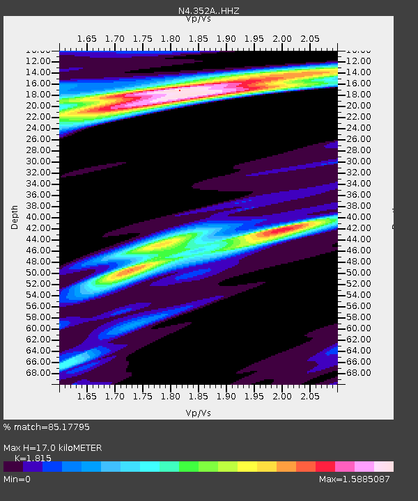
| Estimated Moho Depth: |
17.0 km |
| Estimated Crust Vp/Vs: |
1.82 |
| Assumed Crust Vp: |
6.347 km/s |
| Estimated Crust Vs: |
3.497 km/s |
| Estimated Crust Poisson's Ratio: |
0.28 |
|
| Radial Match: |
85.17795 % |
| Radial Bump: |
370 |
| Transverse Match: |
64.73862 % |
| Transverse Bump: |
400 |
| SOD ConfigId: |
7422571 |
| Insert Time: |
2019-04-22 14:56:14.400 +0000 |
| GWidth: |
2.5 |
| Max Bumps: |
400 |
| Tol: |
0.001 |
|

Signal To Noise
| Channel | StoN | STA | LTA |
| N4:352A: :HHZ:20160518T16:52:30.23999Z | 6.794422 | 3.1328882E-6 | 4.6109707E-7 |
| N4:352A: :HHN:20160518T16:52:30.23999Z | 4.216774 | 1.6062531E-6 | 3.809199E-7 |
| N4:352A: :HHE:20160518T16:52:30.23999Z | 1.1981237 | 6.7381814E-7 | 5.6239446E-7 |
| Arrivals |
| Ps | 2.4 SECOND |
| PpPs | 7.0 SECOND |
| PsPs/PpSs | 9.3 SECOND |


