You are here: Home > Network List > N4 - Central and EAstern US Network Stations List
> Station I45A Fountain, MI, USA > Earthquake Result Viewer
I45A Fountain, MI, USA - Earthquake Result Viewer
| Earthquake location: |
Near Coast Of Ecuador |
| Earthquake latitude/longitude: |
0.5/-79.6 |
| Earthquake time(UTC): |
2016/05/18 (139) 16:46:44 GMT |
| Earthquake Depth: |
31 km |
| Earthquake Magnitude: |
6.8 MO |
| Earthquake Catalog/Contributor: |
NEIC PDE/NEIC ALERT |
|
| Network: |
N4 Central and EAstern US Network |
| Station: |
I45A Fountain, MI, USA |
| Lat/Lon: |
44.04 N/86.23 W |
| Elevation: |
215 m |
|
| Distance: |
43.8 deg |
| Az: |
353.125 deg |
| Baz: |
170.446 deg |
| Ray Param: |
0.07226895 |
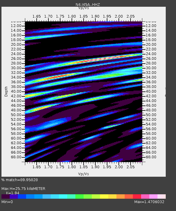
| Estimated Moho Depth: |
25.75 km |
| Estimated Crust Vp/Vs: |
1.94 |
| Assumed Crust Vp: |
6.53 km/s |
| Estimated Crust Vs: |
3.366 km/s |
| Estimated Crust Poisson's Ratio: |
0.32 |
|
| Radial Match: |
89.95828 % |
| Radial Bump: |
400 |
| Transverse Match: |
53.300972 % |
| Transverse Bump: |
400 |
| SOD ConfigId: |
7422571 |
| Insert Time: |
2019-04-22 14:56:40.135 +0000 |
| GWidth: |
2.5 |
| Max Bumps: |
400 |
| Tol: |
0.001 |
|

Signal To Noise
| Channel | StoN | STA | LTA |
| N4:I45A: :HHZ:20160518T16:54:15.910004Z | 9.211915 | 2.8155341E-6 | 3.0564047E-7 |
| N4:I45A: :HHN:20160518T16:54:15.910004Z | 5.1635904 | 2.107632E-6 | 4.0817184E-7 |
| N4:I45A: :HHE:20160518T16:54:15.910004Z | 1.9466962 | 7.9945863E-7 | 4.1067457E-7 |
| Arrivals |
| Ps | 3.9 SECOND |
| PpPs | 11 SECOND |
| PsPs/PpSs | 15 SECOND |


