You are here: Home > Network List > N4 - Central and EAstern US Network Stations List
> Station M50A Fremont, OH, USA > Earthquake Result Viewer
M50A Fremont, OH, USA - Earthquake Result Viewer
| Earthquake location: |
Near Coast Of Ecuador |
| Earthquake latitude/longitude: |
0.5/-79.6 |
| Earthquake time(UTC): |
2016/05/18 (139) 16:46:44 GMT |
| Earthquake Depth: |
31 km |
| Earthquake Magnitude: |
6.8 MO |
| Earthquake Catalog/Contributor: |
NEIC PDE/NEIC ALERT |
|
| Network: |
N4 Central and EAstern US Network |
| Station: |
M50A Fremont, OH, USA |
| Lat/Lon: |
41.40 N/83.04 W |
| Elevation: |
176 m |
|
| Distance: |
40.9 deg |
| Az: |
356.088 deg |
| Baz: |
174.796 deg |
| Ray Param: |
0.07408692 |
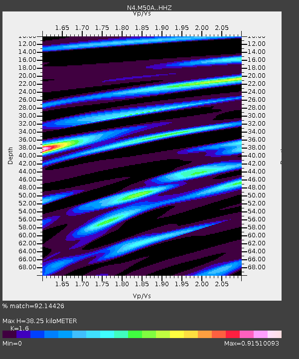
| Estimated Moho Depth: |
38.25 km |
| Estimated Crust Vp/Vs: |
1.60 |
| Assumed Crust Vp: |
6.498 km/s |
| Estimated Crust Vs: |
4.061 km/s |
| Estimated Crust Poisson's Ratio: |
0.18 |
|
| Radial Match: |
92.14426 % |
| Radial Bump: |
303 |
| Transverse Match: |
61.55929 % |
| Transverse Bump: |
400 |
| SOD ConfigId: |
7422571 |
| Insert Time: |
2019-04-22 14:56:59.191 +0000 |
| GWidth: |
2.5 |
| Max Bumps: |
400 |
| Tol: |
0.001 |
|

Signal To Noise
| Channel | StoN | STA | LTA |
| N4:M50A: :HHZ:20160518T16:53:52.23999Z | 17.430813 | 3.400739E-6 | 1.9509928E-7 |
| N4:M50A: :HHN:20160518T16:53:52.23999Z | 12.552682 | 2.38488E-6 | 1.8998968E-7 |
| N4:M50A: :HHE:20160518T16:53:52.23999Z | 1.8208046 | 3.6600935E-7 | 2.0101517E-7 |
| Arrivals |
| Ps | 3.8 SECOND |
| PpPs | 14 SECOND |
| PsPs/PpSs | 18 SECOND |


