You are here: Home > Network List > N4 - Central and EAstern US Network Stations List
> Station V52A Sevierville, TN, USA > Earthquake Result Viewer
V52A Sevierville, TN, USA - Earthquake Result Viewer
| Earthquake location: |
Near Coast Of Ecuador |
| Earthquake latitude/longitude: |
0.5/-79.6 |
| Earthquake time(UTC): |
2016/05/18 (139) 16:46:44 GMT |
| Earthquake Depth: |
31 km |
| Earthquake Magnitude: |
6.8 MO |
| Earthquake Catalog/Contributor: |
NEIC PDE/NEIC ALERT |
|
| Network: |
N4 Central and EAstern US Network |
| Station: |
V52A Sevierville, TN, USA |
| Lat/Lon: |
35.84 N/83.60 W |
| Elevation: |
328 m |
|
| Distance: |
35.4 deg |
| Az: |
354.447 deg |
| Baz: |
173.16 deg |
| Ray Param: |
0.07719426 |
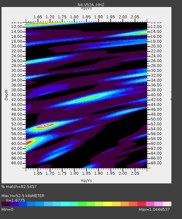
| Estimated Moho Depth: |
52.5 km |
| Estimated Crust Vp/Vs: |
1.68 |
| Assumed Crust Vp: |
6.35 km/s |
| Estimated Crust Vs: |
3.785 km/s |
| Estimated Crust Poisson's Ratio: |
0.22 |
|
| Radial Match: |
92.5457 % |
| Radial Bump: |
357 |
| Transverse Match: |
64.718376 % |
| Transverse Bump: |
400 |
| SOD ConfigId: |
7422571 |
| Insert Time: |
2019-04-22 14:57:42.610 +0000 |
| GWidth: |
2.5 |
| Max Bumps: |
400 |
| Tol: |
0.001 |
|

Signal To Noise
| Channel | StoN | STA | LTA |
| N4:V52A: :HHZ:20160518T16:53:06.190002Z | 17.54287 | 2.970609E-6 | 1.6933427E-7 |
| N4:V52A: :HHN:20160518T16:53:06.190002Z | 11.441001 | 1.7626824E-6 | 1.5406715E-7 |
| N4:V52A: :HHE:20160518T16:53:06.190002Z | 2.3679957 | 3.931312E-7 | 1.6601854E-7 |
| Arrivals |
| Ps | 6.1 SECOND |
| PpPs | 20 SECOND |
| PsPs/PpSs | 27 SECOND |


