You are here: Home > Network List > N4 - Central and EAstern US Network Stations List
> Station Z38B Mount Pleasant, TX, USA > Earthquake Result Viewer
Z38B Mount Pleasant, TX, USA - Earthquake Result Viewer
| Earthquake location: |
Near Coast Of Ecuador |
| Earthquake latitude/longitude: |
0.5/-79.6 |
| Earthquake time(UTC): |
2016/05/18 (139) 16:46:44 GMT |
| Earthquake Depth: |
31 km |
| Earthquake Magnitude: |
6.8 MO |
| Earthquake Catalog/Contributor: |
NEIC PDE/NEIC ALERT |
|
| Network: |
N4 Central and EAstern US Network |
| Station: |
Z38B Mount Pleasant, TX, USA |
| Lat/Lon: |
33.26 N/94.99 W |
| Elevation: |
115 m |
|
| Distance: |
35.7 deg |
| Az: |
337.652 deg |
| Baz: |
153.013 deg |
| Ray Param: |
0.07704248 |
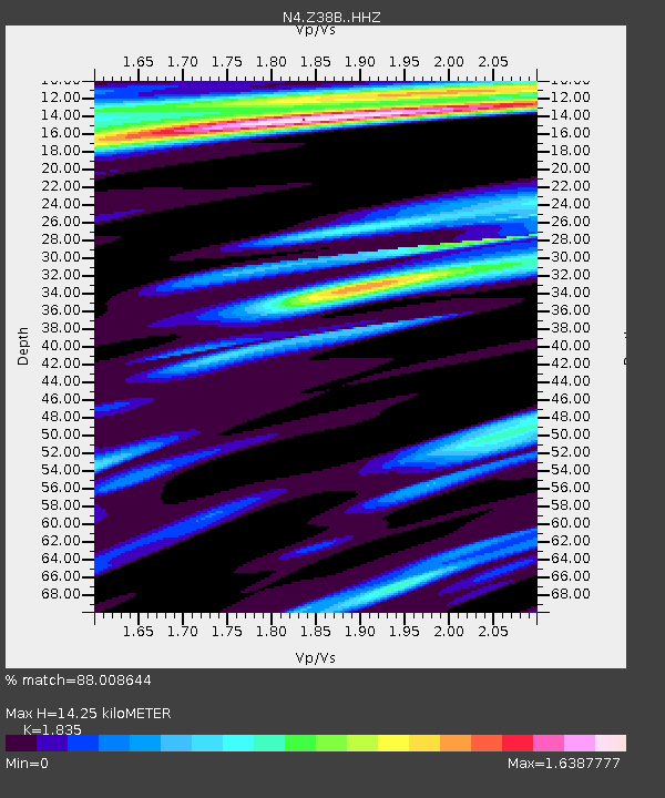
| Estimated Moho Depth: |
14.25 km |
| Estimated Crust Vp/Vs: |
1.84 |
| Assumed Crust Vp: |
6.245 km/s |
| Estimated Crust Vs: |
3.403 km/s |
| Estimated Crust Poisson's Ratio: |
0.29 |
|
| Radial Match: |
88.008644 % |
| Radial Bump: |
323 |
| Transverse Match: |
73.35122 % |
| Transverse Bump: |
400 |
| SOD ConfigId: |
7422571 |
| Insert Time: |
2019-04-22 14:57:57.080 +0000 |
| GWidth: |
2.5 |
| Max Bumps: |
400 |
| Tol: |
0.001 |
|

Signal To Noise
| Channel | StoN | STA | LTA |
| N4:Z38B: :HHZ:20160518T16:53:08.679993Z | 11.161404 | 1.5728641E-6 | 1.4091992E-7 |
| N4:Z38B: :HHN:20160518T16:53:08.679993Z | 2.825777 | 6.9008905E-7 | 2.4421215E-7 |
| N4:Z38B: :HHE:20160518T16:53:08.679993Z | 1.0542227 | 4.002283E-7 | 3.79643E-7 |
| Arrivals |
| Ps | 2.0 SECOND |
| PpPs | 6.0 SECOND |
| PsPs/PpSs | 8.1 SECOND |


