You are here: Home > Network List > NN - Western Great Basin/Eastern Sierra Nevada Stations List
> Station OUT1 Outlaw Springs Mine, Nye County, NV, USA > Earthquake Result Viewer
OUT1 Outlaw Springs Mine, Nye County, NV, USA - Earthquake Result Viewer
| Earthquake location: |
Near Coast Of Ecuador |
| Earthquake latitude/longitude: |
0.5/-79.6 |
| Earthquake time(UTC): |
2016/05/18 (139) 16:46:44 GMT |
| Earthquake Depth: |
31 km |
| Earthquake Magnitude: |
6.8 MO |
| Earthquake Catalog/Contributor: |
NEIC PDE/NEIC ALERT |
|
| Network: |
NN Western Great Basin/Eastern Sierra Nevada |
| Station: |
OUT1 Outlaw Springs Mine, Nye County, NV, USA |
| Lat/Lon: |
38.33 N/117.52 W |
| Elevation: |
1652 m |
|
| Distance: |
51.3 deg |
| Az: |
321.752 deg |
| Baz: |
128.086 deg |
| Ray Param: |
0.067471415 |
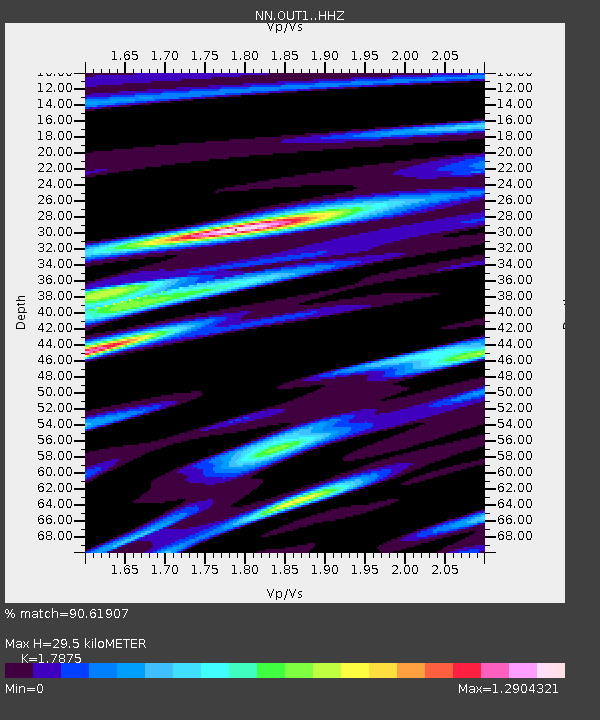
| Estimated Moho Depth: |
29.5 km |
| Estimated Crust Vp/Vs: |
1.79 |
| Assumed Crust Vp: |
6.276 km/s |
| Estimated Crust Vs: |
3.511 km/s |
| Estimated Crust Poisson's Ratio: |
0.27 |
|
| Radial Match: |
90.61907 % |
| Radial Bump: |
342 |
| Transverse Match: |
84.46694 % |
| Transverse Bump: |
400 |
| SOD ConfigId: |
7422571 |
| Insert Time: |
2019-04-22 14:58:21.717 +0000 |
| GWidth: |
2.5 |
| Max Bumps: |
400 |
| Tol: |
0.001 |
|

Signal To Noise
| Channel | StoN | STA | LTA |
| NN:OUT1: :HHZ:20160518T16:55:14.075012Z | 9.341061 | 2.7260646E-7 | 2.9183672E-8 |
| NN:OUT1: :HHN:20160518T16:55:14.075012Z | 1.3504618 | 8.797118E-8 | 6.514155E-8 |
| NN:OUT1: :HHE:20160518T16:55:14.075012Z | 2.8587673 | 1.321993E-7 | 4.6243464E-8 |
| Arrivals |
| Ps | 3.9 SECOND |
| PpPs | 12 SECOND |
| PsPs/PpSs | 16 SECOND |


