You are here: Home > Network List > OK - Oklahoma Seismic Network Stations List
> Station ELIS Ellis County, Oklahoma > Earthquake Result Viewer
ELIS Ellis County, Oklahoma - Earthquake Result Viewer
| Earthquake location: |
Near Coast Of Ecuador |
| Earthquake latitude/longitude: |
0.5/-79.6 |
| Earthquake time(UTC): |
2016/05/18 (139) 16:46:44 GMT |
| Earthquake Depth: |
31 km |
| Earthquake Magnitude: |
6.8 MO |
| Earthquake Catalog/Contributor: |
NEIC PDE/NEIC ALERT |
|
| Network: |
OK Oklahoma Seismic Network |
| Station: |
ELIS Ellis County, Oklahoma |
| Lat/Lon: |
36.07 N/99.42 W |
| Elevation: |
641 m |
|
| Distance: |
39.9 deg |
| Az: |
334.699 deg |
| Baz: |
148.166 deg |
| Ray Param: |
0.074649215 |
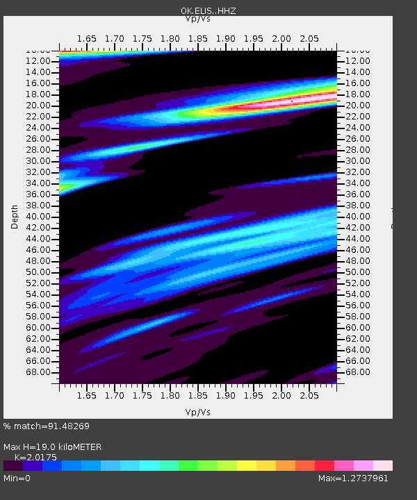
| Estimated Moho Depth: |
19.0 km |
| Estimated Crust Vp/Vs: |
2.02 |
| Assumed Crust Vp: |
6.426 km/s |
| Estimated Crust Vs: |
3.185 km/s |
| Estimated Crust Poisson's Ratio: |
0.34 |
|
| Radial Match: |
91.48269 % |
| Radial Bump: |
400 |
| Transverse Match: |
83.862114 % |
| Transverse Bump: |
400 |
| SOD ConfigId: |
7422571 |
| Insert Time: |
2019-04-22 14:58:48.962 +0000 |
| GWidth: |
2.5 |
| Max Bumps: |
400 |
| Tol: |
0.001 |
|

Signal To Noise
| Channel | StoN | STA | LTA |
| OK:ELIS: :HHZ:20160518T16:53:44.372986Z | 11.526764 | 3.0324202E-6 | 2.6307646E-7 |
| OK:ELIS: :HHN:20160518T16:53:44.372986Z | 1.9844804 | 1.2977041E-6 | 6.539264E-7 |
| OK:ELIS: :HHE:20160518T16:53:44.372986Z | 1.8097976 | 7.1152397E-7 | 3.931511E-7 |
| Arrivals |
| Ps | 3.2 SECOND |
| PpPs | 8.4 SECOND |
| PsPs/PpSs | 12 SECOND |


