You are here: Home > Network List > PE - Penn State Network Stations List
> Station PACW Cowans Gap State Park, Fort Loudon, PA > Earthquake Result Viewer
PACW Cowans Gap State Park, Fort Loudon, PA - Earthquake Result Viewer
| Earthquake location: |
Near Coast Of Ecuador |
| Earthquake latitude/longitude: |
0.5/-79.6 |
| Earthquake time(UTC): |
2016/05/18 (139) 16:46:44 GMT |
| Earthquake Depth: |
31 km |
| Earthquake Magnitude: |
6.8 MO |
| Earthquake Catalog/Contributor: |
NEIC PDE/NEIC ALERT |
|
| Network: |
PE Penn State Network |
| Station: |
PACW Cowans Gap State Park, Fort Loudon, PA |
| Lat/Lon: |
40.00 N/77.92 W |
| Elevation: |
394 m |
|
| Distance: |
39.4 deg |
| Az: |
2.078 deg |
| Baz: |
182.705 deg |
| Ray Param: |
0.07496339 |
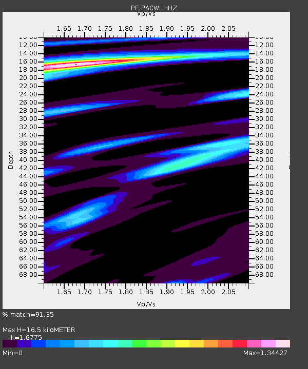
| Estimated Moho Depth: |
16.5 km |
| Estimated Crust Vp/Vs: |
1.68 |
| Assumed Crust Vp: |
6.419 km/s |
| Estimated Crust Vs: |
3.827 km/s |
| Estimated Crust Poisson's Ratio: |
0.22 |
|
| Radial Match: |
91.35 % |
| Radial Bump: |
289 |
| Transverse Match: |
68.279495 % |
| Transverse Bump: |
400 |
| SOD ConfigId: |
7422571 |
| Insert Time: |
2019-04-22 14:59:19.636 +0000 |
| GWidth: |
2.5 |
| Max Bumps: |
400 |
| Tol: |
0.001 |
|

Signal To Noise
| Channel | StoN | STA | LTA |
| PE:PACW: :HHZ:20160518T16:53:39.859985Z | 17.906244 | 2.669494E-6 | 1.4908176E-7 |
| PE:PACW: :HHN:20160518T16:53:39.859985Z | 9.826694 | 1.5962914E-6 | 1.6244441E-7 |
| PE:PACW: :HHE:20160518T16:53:39.859985Z | 2.667642 | 4.6665093E-7 | 1.7493012E-7 |
| Arrivals |
| Ps | 1.9 SECOND |
| PpPs | 6.4 SECOND |
| PsPs/PpSs | 8.3 SECOND |


