You are here: Home > Network List > TA - USArray Transportable Network (new EarthScope stations) Stations List
> Station ABTX Abilene, Hawley, TX, USA > Earthquake Result Viewer
ABTX Abilene, Hawley, TX, USA - Earthquake Result Viewer
| Earthquake location: |
Near Coast Of Ecuador |
| Earthquake latitude/longitude: |
0.5/-79.6 |
| Earthquake time(UTC): |
2016/05/18 (139) 16:46:44 GMT |
| Earthquake Depth: |
31 km |
| Earthquake Magnitude: |
6.8 MO |
| Earthquake Catalog/Contributor: |
NEIC PDE/NEIC ALERT |
|
| Network: |
TA USArray Transportable Network (new EarthScope stations) |
| Station: |
ABTX Abilene, Hawley, TX, USA |
| Lat/Lon: |
32.62 N/99.64 W |
| Elevation: |
502 m |
|
| Distance: |
37.1 deg |
| Az: |
331.432 deg |
| Baz: |
145.483 deg |
| Ray Param: |
0.07624809 |
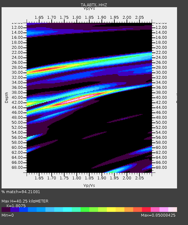
| Estimated Moho Depth: |
40.25 km |
| Estimated Crust Vp/Vs: |
1.81 |
| Assumed Crust Vp: |
6.426 km/s |
| Estimated Crust Vs: |
3.555 km/s |
| Estimated Crust Poisson's Ratio: |
0.28 |
|
| Radial Match: |
94.21081 % |
| Radial Bump: |
326 |
| Transverse Match: |
66.93232 % |
| Transverse Bump: |
400 |
| SOD ConfigId: |
7422571 |
| Insert Time: |
2019-04-22 15:00:57.876 +0000 |
| GWidth: |
2.5 |
| Max Bumps: |
400 |
| Tol: |
0.001 |
|

Signal To Noise
| Channel | StoN | STA | LTA |
| TA:ABTX: :HHZ:20160518T16:53:21.140015Z | 7.6572375 | 1.1623598E-6 | 1.5179884E-7 |
| TA:ABTX: :HHN:20160518T16:53:21.140015Z | 7.167363 | 6.506604E-7 | 9.078101E-8 |
| TA:ABTX: :HHE:20160518T16:53:21.140015Z | 3.8089285 | 4.1881955E-7 | 1.0995731E-7 |
| Arrivals |
| Ps | 5.4 SECOND |
| PpPs | 16 SECOND |
| PsPs/PpSs | 22 SECOND |


