You are here: Home > Network List > TA - USArray Transportable Network (new EarthScope stations) Stations List
> Station F04D Rainier, OR, USA > Earthquake Result Viewer
F04D Rainier, OR, USA - Earthquake Result Viewer
| Earthquake location: |
Near Coast Of Ecuador |
| Earthquake latitude/longitude: |
0.5/-79.6 |
| Earthquake time(UTC): |
2016/05/18 (139) 16:46:44 GMT |
| Earthquake Depth: |
31 km |
| Earthquake Magnitude: |
6.8 MO |
| Earthquake Catalog/Contributor: |
NEIC PDE/NEIC ALERT |
|
| Network: |
TA USArray Transportable Network (new EarthScope stations) |
| Station: |
F04D Rainier, OR, USA |
| Lat/Lon: |
46.08 N/123.01 W |
| Elevation: |
236 m |
|
| Distance: |
59.2 deg |
| Az: |
326.197 deg |
| Baz: |
126.939 deg |
| Ray Param: |
0.062280145 |
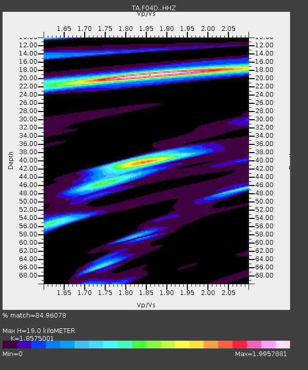
| Estimated Moho Depth: |
19.0 km |
| Estimated Crust Vp/Vs: |
1.86 |
| Assumed Crust Vp: |
6.566 km/s |
| Estimated Crust Vs: |
3.535 km/s |
| Estimated Crust Poisson's Ratio: |
0.30 |
|
| Radial Match: |
84.96078 % |
| Radial Bump: |
400 |
| Transverse Match: |
69.7833 % |
| Transverse Bump: |
400 |
| SOD ConfigId: |
7422571 |
| Insert Time: |
2019-04-22 15:01:02.481 +0000 |
| GWidth: |
2.5 |
| Max Bumps: |
400 |
| Tol: |
0.001 |
|

Signal To Noise
| Channel | StoN | STA | LTA |
| TA:F04D: :HHZ:20160518T16:56:11.320007Z | 5.8976164 | 1.3733004E-6 | 2.3285685E-7 |
| TA:F04D: :HHN:20160518T16:56:11.320007Z | 0.7008359 | 3.887712E-7 | 5.5472503E-7 |
| TA:F04D: :HHE:20160518T16:56:11.320007Z | 1.6135616 | 8.3781896E-7 | 5.192358E-7 |
| Arrivals |
| Ps | 2.6 SECOND |
| PpPs | 7.9 SECOND |
| PsPs/PpSs | 10 SECOND |


