You are here: Home > Network List > TA - USArray Transportable Network (new EarthScope stations) Stations List
> Station J01E Myrtle Point, OR, USA > Earthquake Result Viewer
J01E Myrtle Point, OR, USA - Earthquake Result Viewer

| Earthquake location: |
Near Coast Of Ecuador |
| Earthquake latitude/longitude: |
0.5/-79.6 |
| Earthquake time(UTC): |
2016/05/18 (139) 16:46:44 GMT |
| Earthquake Depth: |
31 km |
| Earthquake Magnitude: |
6.8 MO |
| Earthquake Catalog/Contributor: |
NEIC PDE/NEIC ALERT |
|
| Network: |
TA USArray Transportable Network (new EarthScope stations) |
| Station: |
J01E Myrtle Point, OR, USA |
| Lat/Lon: |
43.16 N/123.93 W |
| Elevation: |
128 m |
|
| Distance: |
58.0 deg |
| Az: |
322.972 deg |
| Baz: |
124.615 deg |
| Ray Param: |
0.063047916 |
| Estimated Moho Depth: |
12.5 km |
| Estimated Crust Vp/Vs: |
1.78 |
| Assumed Crust Vp: |
6.522 km/s |
| Estimated Crust Vs: |
3.669 km/s |
| Estimated Crust Poisson's Ratio: |
0.27 |
|
| Radial Match: |
80.87296 % |
| Radial Bump: |
400 |
| Transverse Match: |
84.12644 % |
| Transverse Bump: |
400 |
| SOD ConfigId: |
7422571 |
| Insert Time: |
2019-04-22 15:01:15.219 +0000 |
| GWidth: |
2.5 |
| Max Bumps: |
400 |
| Tol: |
0.001 |
|
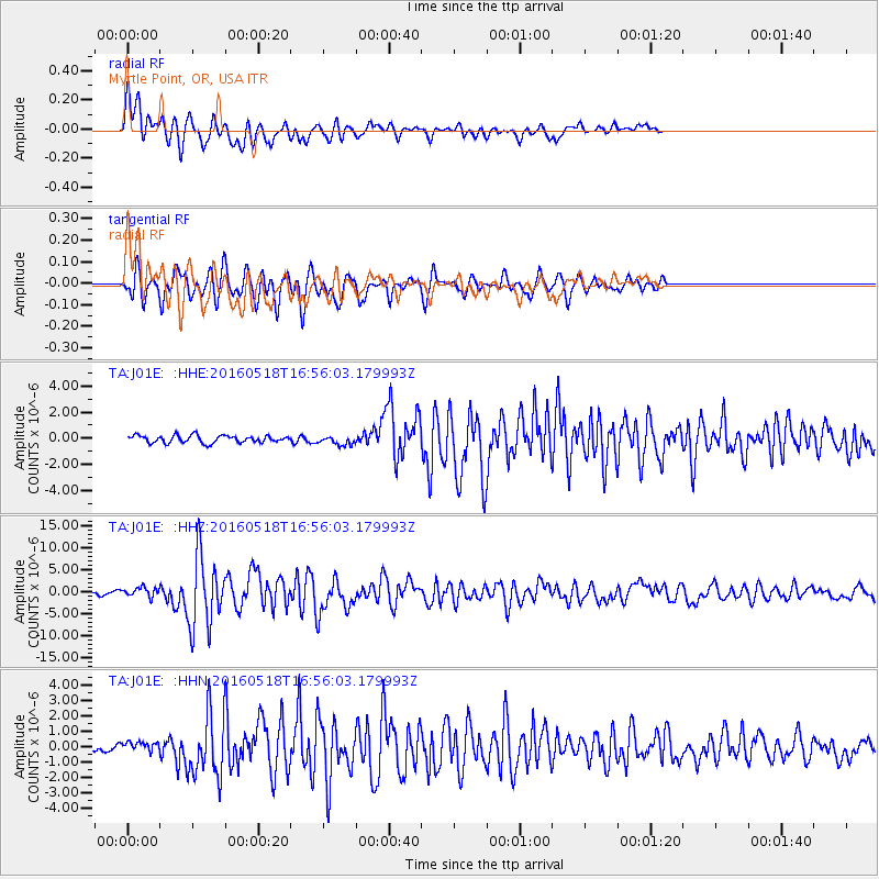
Signal To Noise
| Channel | StoN | STA | LTA |
| TA:J01E: :HHZ:20160518T16:56:03.179993Z | 3.1093774 | 1.074056E-6 | 3.4542475E-7 |
| TA:J01E: :HHN:20160518T16:56:03.179993Z | 1.5035667 | 3.2656536E-7 | 2.1719379E-7 |
| TA:J01E: :HHE:20160518T16:56:03.179993Z | 1.2682148 | 3.5291944E-7 | 2.7828048E-7 |
| Arrivals |
| Ps | 1.6 SECOND |
| PpPs | 5.1 SECOND |
| PsPs/PpSs | 6.6 SECOND |


