You are here: Home > Network List > TA - USArray Transportable Network (new EarthScope stations) Stations List
> Station L20K Farewell, AK, USA > Earthquake Result Viewer
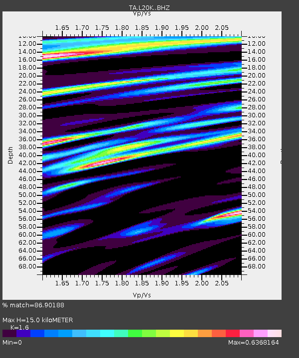
L20K Farewell, AK, USA - Earthquake Result Viewer
| Earthquake location: |
Near Coast Of Ecuador |
| Earthquake latitude/longitude: |
0.5/-79.6 |
| Earthquake time(UTC): |
2016/05/18 (139) 16:46:44 GMT |
| Earthquake Depth: |
31 km |
| Earthquake Magnitude: |
6.8 MO |
| Earthquake Catalog/Contributor: |
NEIC PDE/NEIC ALERT |
|
| Network: |
TA USArray Transportable Network (new EarthScope stations) |
| Station: |
L20K Farewell, AK, USA |
| Lat/Lon: |
62.48 N/153.88 W |
| Elevation: |
673 m |
|
| Distance: |
82.3 deg |
| Az: |
333.187 deg |
| Baz: |
103.823 deg |
| Ray Param: |
0.046915993 |
| Estimated Moho Depth: |
15.0 km |
| Estimated Crust Vp/Vs: |
1.60 |
| Assumed Crust Vp: |
6.566 km/s |
| Estimated Crust Vs: |
4.104 km/s |
| Estimated Crust Poisson's Ratio: |
0.18 |
|
| Radial Match: |
86.90188 % |
| Radial Bump: |
400 |
| Transverse Match: |
85.82778 % |
| Transverse Bump: |
400 |
| SOD ConfigId: |
7422571 |
| Insert Time: |
2019-04-22 15:01:33.498 +0000 |
| GWidth: |
2.5 |
| Max Bumps: |
400 |
| Tol: |
0.001 |
|

Signal To Noise
| Channel | StoN | STA | LTA |
| TA:L20K: :BHZ:20160518T16:58:31.424988Z | 17.50473 | 1.3749304E-6 | 7.8546215E-8 |
| TA:L20K: :BHN:20160518T16:58:31.424988Z | 2.054381 | 2.3136238E-7 | 1.1261903E-7 |
| TA:L20K: :BHE:20160518T16:58:31.424988Z | 6.0998726 | 5.8076415E-7 | 9.5209224E-8 |
| Arrivals |
| Ps | 1.4 SECOND |
| PpPs | 5.8 SECOND |
| PsPs/PpSs | 7.2 SECOND |


