You are here: Home > Network List > TA - USArray Transportable Network (new EarthScope stations) Stations List
> Station MDND Maddock, ND, USA > Earthquake Result Viewer
MDND Maddock, ND, USA - Earthquake Result Viewer
| Earthquake location: |
Near Coast Of Ecuador |
| Earthquake latitude/longitude: |
0.5/-79.6 |
| Earthquake time(UTC): |
2016/05/18 (139) 16:46:44 GMT |
| Earthquake Depth: |
31 km |
| Earthquake Magnitude: |
6.8 MO |
| Earthquake Catalog/Contributor: |
NEIC PDE/NEIC ALERT |
|
| Network: |
TA USArray Transportable Network (new EarthScope stations) |
| Station: |
MDND Maddock, ND, USA |
| Lat/Lon: |
47.85 N/99.60 W |
| Elevation: |
479 m |
|
| Distance: |
50.3 deg |
| Az: |
342.604 deg |
| Baz: |
153.651 deg |
| Ray Param: |
0.06810475 |
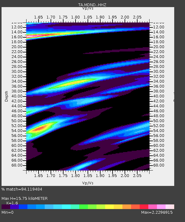
| Estimated Moho Depth: |
15.75 km |
| Estimated Crust Vp/Vs: |
1.60 |
| Assumed Crust Vp: |
6.53 km/s |
| Estimated Crust Vs: |
4.082 km/s |
| Estimated Crust Poisson's Ratio: |
0.18 |
|
| Radial Match: |
94.119484 % |
| Radial Bump: |
311 |
| Transverse Match: |
70.55571 % |
| Transverse Bump: |
400 |
| SOD ConfigId: |
7422571 |
| Insert Time: |
2019-04-22 15:01:49.269 +0000 |
| GWidth: |
2.5 |
| Max Bumps: |
400 |
| Tol: |
0.001 |
|
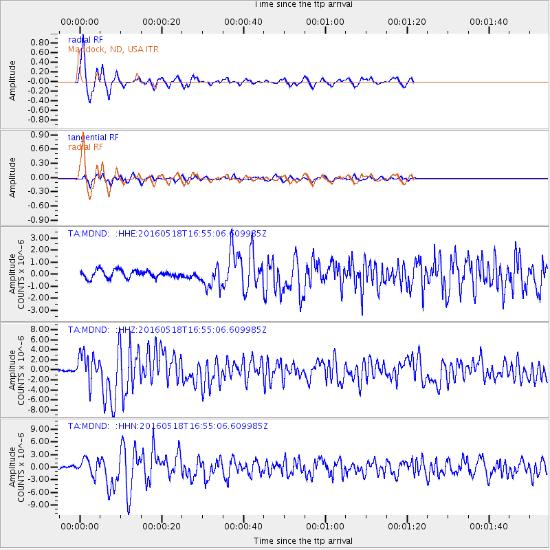
Signal To Noise
| Channel | StoN | STA | LTA |
| TA:MDND: :HHZ:20160518T16:55:06.609985Z | 20.299685 | 2.8264524E-6 | 1.3923628E-7 |
| TA:MDND: :HHN:20160518T16:55:06.609985Z | 5.527291 | 1.8887444E-6 | 3.4171248E-7 |
| TA:MDND: :HHE:20160518T16:55:06.609985Z | 2.9024034 | 9.1061344E-7 | 3.1374464E-7 |
| Arrivals |
| Ps | 1.5 SECOND |
| PpPs | 5.9 SECOND |
| PsPs/PpSs | 7.4 SECOND |


