You are here: Home > Network List > TA - USArray Transportable Network (new EarthScope stations) Stations List
> Station MSTX Muleshoe, TX, USA > Earthquake Result Viewer
MSTX Muleshoe, TX, USA - Earthquake Result Viewer
| Earthquake location: |
Near Coast Of Ecuador |
| Earthquake latitude/longitude: |
0.5/-79.6 |
| Earthquake time(UTC): |
2016/05/18 (139) 16:46:44 GMT |
| Earthquake Depth: |
31 km |
| Earthquake Magnitude: |
6.8 MO |
| Earthquake Catalog/Contributor: |
NEIC PDE/NEIC ALERT |
|
| Network: |
TA USArray Transportable Network (new EarthScope stations) |
| Station: |
MSTX Muleshoe, TX, USA |
| Lat/Lon: |
33.97 N/102.77 W |
| Elevation: |
1167 m |
|
| Distance: |
39.8 deg |
| Az: |
329.306 deg |
| Baz: |
142.107 deg |
| Ray Param: |
0.0747362 |
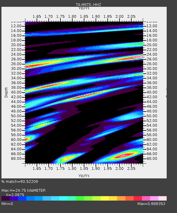
| Estimated Moho Depth: |
24.75 km |
| Estimated Crust Vp/Vs: |
2.10 |
| Assumed Crust Vp: |
6.129 km/s |
| Estimated Crust Vs: |
2.922 km/s |
| Estimated Crust Poisson's Ratio: |
0.35 |
|
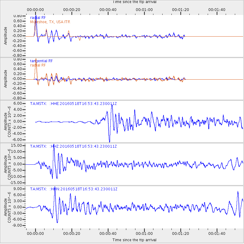
| Radial Match: |
90.52209 % |
| Radial Bump: |
315 |
| Transverse Match: |
71.31802 % |
| Transverse Bump: |
392 |
| SOD ConfigId: |
7422571 |
| Insert Time: |
2019-04-22 15:01:49.811 +0000 |
| GWidth: |
2.5 |
| Max Bumps: |
400 |
| Tol: |
0.001 |
|
Signal To Noise
| Channel | StoN | STA | LTA |
| TA:MSTX: :HHZ:20160518T16:53:43.230011Z | 10.23288 | 1.3059048E-6 | 1.276185E-7 |
| TA:MSTX: :HHN:20160518T16:53:43.230011Z | 4.980851 | 6.7395433E-7 | 1.3530907E-7 |
| TA:MSTX: :HHE:20160518T16:53:43.230011Z | 3.8208447 | 4.263217E-7 | 1.1157786E-7 |
| Arrivals |
| Ps | 4.7 SECOND |
| PpPs | 12 SECOND |
| PsPs/PpSs | 17 SECOND |


