You are here: Home > Network List > UW - Pacific Northwest Regional Seismic Network Stations List
> Station FISH Seaside, OR, USA > Earthquake Result Viewer
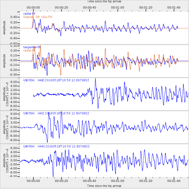
FISH Seaside, OR, USA - Earthquake Result Viewer
*The percent match for this event was below the threshold and hence no stack was calculated.
| Earthquake location: |
Near Coast Of Ecuador |
| Earthquake latitude/longitude: |
0.5/-79.6 |
| Earthquake time(UTC): |
2016/05/18 (139) 16:46:44 GMT |
| Earthquake Depth: |
31 km |
| Earthquake Magnitude: |
6.8 MO |
| Earthquake Catalog/Contributor: |
NEIC PDE/NEIC ALERT |
|
| Network: |
UW Pacific Northwest Regional Seismic Network |
| Station: |
FISH Seaside, OR, USA |
| Lat/Lon: |
45.93 N/123.56 W |
| Elevation: |
325 m |
|
| Distance: |
59.4 deg |
| Az: |
325.79 deg |
| Baz: |
126.338 deg |
| Ray Param: |
$rayparam |
*The percent match for this event was below the threshold and hence was not used in the summary stack. |
|
| Radial Match: |
78.73746 % |
| Radial Bump: |
400 |
| Transverse Match: |
77.53468 % |
| Transverse Bump: |
400 |
| SOD ConfigId: |
7422571 |
| Insert Time: |
2019-04-22 15:02:39.191 +0000 |
| GWidth: |
2.5 |
| Max Bumps: |
400 |
| Tol: |
0.001 |
|
Signal To Noise
| Channel | StoN | STA | LTA |
| UW:FISH: :HHZ:20160518T16:56:12.807983Z | 5.4945498 | 1.2786221E-6 | 2.3270734E-7 |
| UW:FISH: :HHN:20160518T16:56:12.807983Z | 0.8168542 | 3.509434E-7 | 4.2962796E-7 |
| UW:FISH: :HHE:20160518T16:56:12.807983Z | 1.7615372 | 6.5816346E-7 | 3.736302E-7 |
| Arrivals |
| Ps | |
| PpPs | |
| PsPs/PpSs | |


