You are here: Home > Network List > XD14 - Illuminating the architecture of the greater Mount St. Helens magmatic systems f Stations List
> Station MH04 "Mount St Helens, WA" > Earthquake Result Viewer
MH04 "Mount St Helens, WA" - Earthquake Result Viewer
| Earthquake location: |
Near Coast Of Ecuador |
| Earthquake latitude/longitude: |
0.5/-79.6 |
| Earthquake time(UTC): |
2016/05/18 (139) 16:46:44 GMT |
| Earthquake Depth: |
31 km |
| Earthquake Magnitude: |
6.8 MO |
| Earthquake Catalog/Contributor: |
NEIC PDE/NEIC ALERT |
|
| Network: |
XD Illuminating the architecture of the greater Mount St. Helens magmatic systems f |
| Station: |
MH04 "Mount St Helens, WA" |
| Lat/Lon: |
46.28 N/122.43 W |
| Elevation: |
920 m |
|
| Distance: |
59.0 deg |
| Az: |
326.666 deg |
| Baz: |
127.6 deg |
| Ray Param: |
0.062414806 |
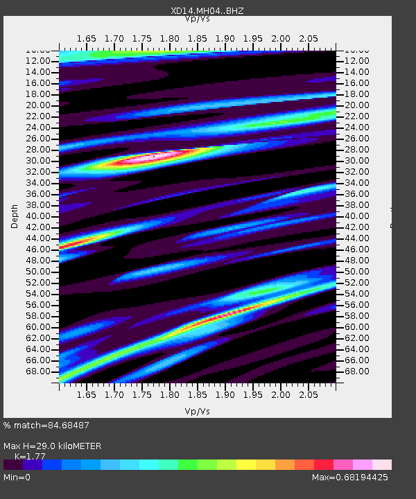
| Estimated Moho Depth: |
29.0 km |
| Estimated Crust Vp/Vs: |
1.77 |
| Assumed Crust Vp: |
6.566 km/s |
| Estimated Crust Vs: |
3.71 km/s |
| Estimated Crust Poisson's Ratio: |
0.27 |
|
| Radial Match: |
84.68487 % |
| Radial Bump: |
272 |
| Transverse Match: |
61.807285 % |
| Transverse Bump: |
400 |
| SOD ConfigId: |
7422571 |
| Insert Time: |
2019-04-22 15:03:33.508 +0000 |
| GWidth: |
2.5 |
| Max Bumps: |
400 |
| Tol: |
0.001 |
|

Signal To Noise
| Channel | StoN | STA | LTA |
| XD:MH04: :BHZ:20160518T16:56:09.914978Z | 6.717238 | 7.70437E-7 | 1.146955E-7 |
| XD:MH04: :BHN:20160518T16:56:09.914978Z | 1.7949638 | 2.8544412E-7 | 1.5902499E-7 |
| XD:MH04: :BHE:20160518T16:56:09.914978Z | 2.2619574 | 1.0241398E-6 | 4.5276707E-7 |
| Arrivals |
| Ps | 3.6 SECOND |
| PpPs | 12 SECOND |
| PsPs/PpSs | 15 SECOND |


