You are here: Home > Network List > XD14 - Illuminating the architecture of the greater Mount St. Helens magmatic systems f Stations List
> Station MJ03 "Mount St Helens, WA" > Earthquake Result Viewer
MJ03 "Mount St Helens, WA" - Earthquake Result Viewer
| Earthquake location: |
Near Coast Of Ecuador |
| Earthquake latitude/longitude: |
0.5/-79.6 |
| Earthquake time(UTC): |
2016/05/18 (139) 16:46:44 GMT |
| Earthquake Depth: |
31 km |
| Earthquake Magnitude: |
6.8 MO |
| Earthquake Catalog/Contributor: |
NEIC PDE/NEIC ALERT |
|
| Network: |
XD Illuminating the architecture of the greater Mount St. Helens magmatic systems f |
| Station: |
MJ03 "Mount St Helens, WA" |
| Lat/Lon: |
46.16 N/122.56 W |
| Elevation: |
397 m |
|
| Distance: |
59.0 deg |
| Az: |
326.486 deg |
| Baz: |
127.408 deg |
| Ray Param: |
0.06241305 |
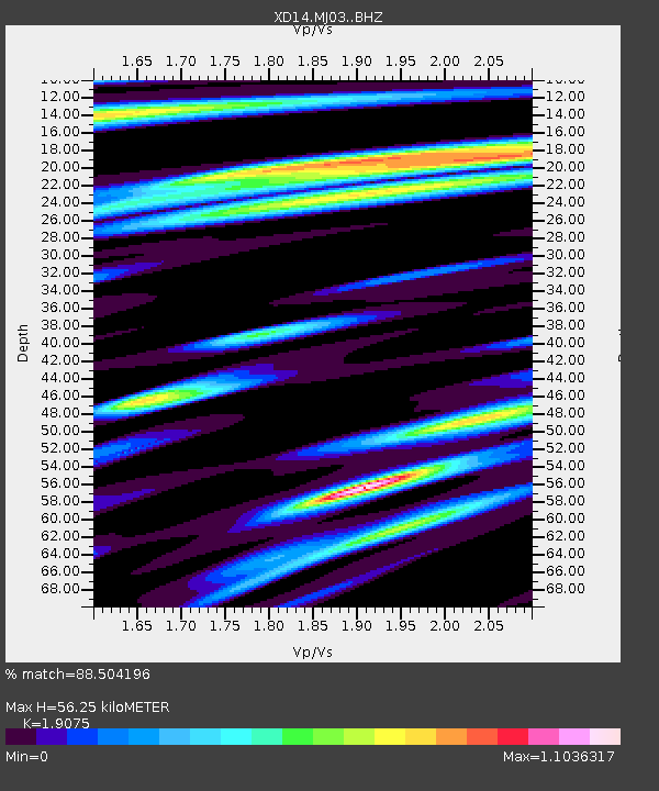
| Estimated Moho Depth: |
56.25 km |
| Estimated Crust Vp/Vs: |
1.91 |
| Assumed Crust Vp: |
6.566 km/s |
| Estimated Crust Vs: |
3.442 km/s |
| Estimated Crust Poisson's Ratio: |
0.31 |
|
| Radial Match: |
88.504196 % |
| Radial Bump: |
400 |
| Transverse Match: |
88.343666 % |
| Transverse Bump: |
400 |
| SOD ConfigId: |
7422571 |
| Insert Time: |
2019-04-22 15:03:42.534 +0000 |
| GWidth: |
2.5 |
| Max Bumps: |
400 |
| Tol: |
0.001 |
|

Signal To Noise
| Channel | StoN | STA | LTA |
| XD:MJ03: :BHZ:20160518T16:56:09.929993Z | 7.750324 | 9.585217E-7 | 1.2367505E-7 |
| XD:MJ03: :BHN:20160518T16:56:09.929993Z | 2.0326922 | 3.6950152E-7 | 1.8177938E-7 |
| XD:MJ03: :BHE:20160518T16:56:09.929993Z | 4.0530477 | 5.033813E-7 | 1.2419821E-7 |
| Arrivals |
| Ps | 8.1 SECOND |
| PpPs | 24 SECOND |
| PsPs/PpSs | 32 SECOND |


