You are here: Home > Network List > TA - USArray Transportable Network (new EarthScope stations) Stations List
> Station BGNE Belgrade, NE, USA > Earthquake Result Viewer
BGNE Belgrade, NE, USA - Earthquake Result Viewer
*The percent match for this event was below the threshold and hence no stack was calculated.
| Earthquake location: |
Southeast Of Honshu, Japan |
| Earthquake latitude/longitude: |
30.9/140.1 |
| Earthquake time(UTC): |
2016/05/21 (142) 06:06:42 GMT |
| Earthquake Depth: |
130 km |
| Earthquake Magnitude: |
5.5 MB |
| Earthquake Catalog/Contributor: |
NEIC PDE/NEIC COMCAT |
|
| Network: |
TA USArray Transportable Network (new EarthScope stations) |
| Station: |
BGNE Belgrade, NE, USA |
| Lat/Lon: |
41.41 N/98.15 W |
| Elevation: |
573 m |
|
| Distance: |
90.2 deg |
| Az: |
39.746 deg |
| Baz: |
313.081 deg |
| Ray Param: |
$rayparam |
*The percent match for this event was below the threshold and hence was not used in the summary stack. |
|
| Radial Match: |
45.18356 % |
| Radial Bump: |
400 |
| Transverse Match: |
50.747562 % |
| Transverse Bump: |
400 |
| SOD ConfigId: |
7422571 |
| Insert Time: |
2019-04-22 15:25:41.405 +0000 |
| GWidth: |
2.5 |
| Max Bumps: |
400 |
| Tol: |
0.001 |
|
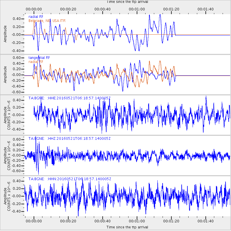
Signal To Noise
| Channel | StoN | STA | LTA |
| TA:BGNE: :HHZ:20160521T06:18:57.140005Z | 2.9807043 | 2.7753737E-7 | 9.311134E-8 |
| TA:BGNE: :HHN:20160521T06:18:57.140005Z | 0.9825235 | 1.5635264E-7 | 1.5913373E-7 |
| TA:BGNE: :HHE:20160521T06:18:57.140005Z | 0.7699571 | 1.213423E-7 | 1.5759618E-7 |
| Arrivals |
| Ps | |
| PpPs | |
| PsPs/PpSs | |


