You are here: Home > Network List > CI - Caltech Regional Seismic Network Stations List
> Station NEE2 Needles Airport > Earthquake Result Viewer
NEE2 Needles Airport - Earthquake Result Viewer
| Earthquake location: |
Ryukyu Islands, Japan |
| Earthquake latitude/longitude: |
28.8/130.0 |
| Earthquake time(UTC): |
2006/08/31 (243) 22:58:25 GMT |
| Earthquake Depth: |
33 km |
| Earthquake Magnitude: |
5.6 MB, 5.2 MS, 5.5 MW |
| Earthquake Catalog/Contributor: |
WHDF/NEIC |
|
| Network: |
CI Caltech Regional Seismic Network |
| Station: |
NEE2 Needles Airport |
| Lat/Lon: |
34.77 N/114.62 W |
| Elevation: |
271 m |
|
| Distance: |
92.1 deg |
| Az: |
48.116 deg |
| Baz: |
307.466 deg |
| Ray Param: |
0.041494973 |
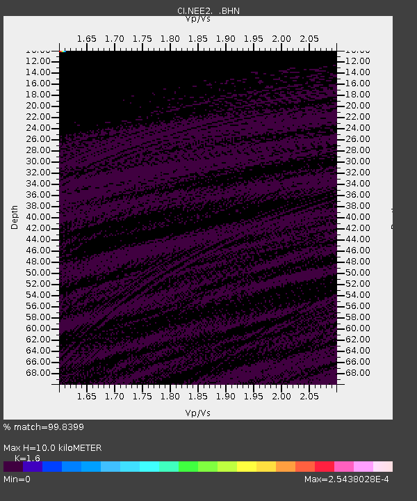
| Estimated Moho Depth: |
10.0 km |
| Estimated Crust Vp/Vs: |
1.60 |
| Assumed Crust Vp: |
6.276 km/s |
| Estimated Crust Vs: |
3.922 km/s |
| Estimated Crust Poisson's Ratio: |
0.18 |
|
| Radial Match: |
99.8399 % |
| Radial Bump: |
19 |
| Transverse Match: |
99.669754 % |
| Transverse Bump: |
33 |
| SOD ConfigId: |
2665 |
| Insert Time: |
2010-02-26 00:23:24.379 +0000 |
| GWidth: |
2.5 |
| Max Bumps: |
400 |
| Tol: |
0.001 |
|
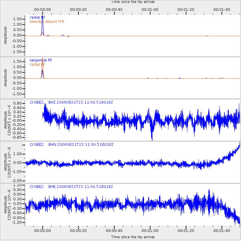
Signal To Noise
| Channel | StoN | STA | LTA |
| CI:NEE2: :BHN:20060831T23:11:00.518018Z | 0.8603514 | 2.0562844E-7 | 2.3900517E-7 |
| CI:NEE2: :BHE:20060831T23:11:00.518018Z | 0.74309754 | 2.0216535E-7 | 2.7205763E-7 |
| CI:NEE2: :BHZ:20060831T23:11:00.518018Z | 0.7990768 | 1.7208693E-7 | 2.1535718E-7 |
| Arrivals |
| Ps | 1.0 SECOND |
| PpPs | 4.1 SECOND |
| PsPs/PpSs | 5.0 SECOND |


