You are here: Home > Network List > TA - USArray Transportable Network (new EarthScope stations) Stations List
> Station Q24A Divide, CO, USA > Earthquake Result Viewer
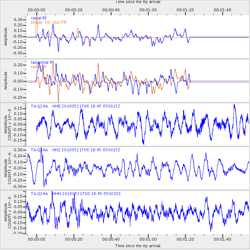
Q24A Divide, CO, USA - Earthquake Result Viewer
*The percent match for this event was below the threshold and hence no stack was calculated.
| Earthquake location: |
Southeast Of Honshu, Japan |
| Earthquake latitude/longitude: |
30.9/140.1 |
| Earthquake time(UTC): |
2016/05/21 (142) 06:06:42 GMT |
| Earthquake Depth: |
130 km |
| Earthquake Magnitude: |
5.5 MB |
| Earthquake Catalog/Contributor: |
NEIC PDE/NEIC COMCAT |
|
| Network: |
TA USArray Transportable Network (new EarthScope stations) |
| Station: |
Q24A Divide, CO, USA |
| Lat/Lon: |
38.96 N/105.15 W |
| Elevation: |
2775 m |
|
| Distance: |
87.7 deg |
| Az: |
45.098 deg |
| Baz: |
308.674 deg |
| Ray Param: |
$rayparam |
*The percent match for this event was below the threshold and hence was not used in the summary stack. |
|
| Radial Match: |
49.33075 % |
| Radial Bump: |
400 |
| Transverse Match: |
70.993935 % |
| Transverse Bump: |
400 |
| SOD ConfigId: |
7422571 |
| Insert Time: |
2019-04-22 15:26:17.391 +0000 |
| GWidth: |
2.5 |
| Max Bumps: |
400 |
| Tol: |
0.001 |
|
Signal To Noise
| Channel | StoN | STA | LTA |
| TA:Q24A: :HHZ:20160521T06:18:45.650015Z | 3.2618198 | 1.8211531E-7 | 5.5832427E-8 |
| TA:Q24A: :HHN:20160521T06:18:45.650015Z | 1.1072847 | 4.8195524E-8 | 4.3525866E-8 |
| TA:Q24A: :HHE:20160521T06:18:45.650015Z | 0.7006508 | 4.2315513E-8 | 6.0394584E-8 |
| Arrivals |
| Ps | |
| PpPs | |
| PsPs/PpSs | |


