You are here: Home > Network List > TA - USArray Transportable Network (new EarthScope stations) Stations List
> Station T25A Trinidad, CO, USA > Earthquake Result Viewer
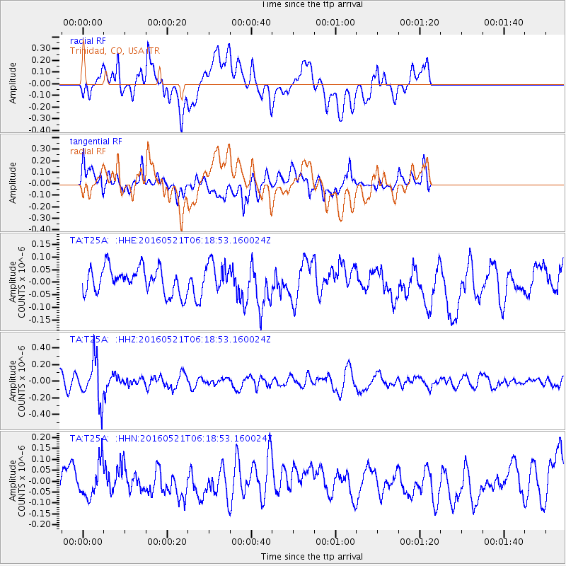
T25A Trinidad, CO, USA - Earthquake Result Viewer
*The percent match for this event was below the threshold and hence no stack was calculated.
| Earthquake location: |
Southeast Of Honshu, Japan |
| Earthquake latitude/longitude: |
30.9/140.1 |
| Earthquake time(UTC): |
2016/05/21 (142) 06:06:42 GMT |
| Earthquake Depth: |
130 km |
| Earthquake Magnitude: |
5.5 MB |
| Earthquake Catalog/Contributor: |
NEIC PDE/NEIC COMCAT |
|
| Network: |
TA USArray Transportable Network (new EarthScope stations) |
| Station: |
T25A Trinidad, CO, USA |
| Lat/Lon: |
37.14 N/104.41 W |
| Elevation: |
2017 m |
|
| Distance: |
89.3 deg |
| Az: |
46.15 deg |
| Baz: |
309.154 deg |
| Ray Param: |
$rayparam |
*The percent match for this event was below the threshold and hence was not used in the summary stack. |
|
| Radial Match: |
47.410145 % |
| Radial Bump: |
400 |
| Transverse Match: |
65.1211 % |
| Transverse Bump: |
400 |
| SOD ConfigId: |
7422571 |
| Insert Time: |
2019-04-22 15:26:22.361 +0000 |
| GWidth: |
2.5 |
| Max Bumps: |
400 |
| Tol: |
0.001 |
|
Signal To Noise
| Channel | StoN | STA | LTA |
| TA:T25A: :HHZ:20160521T06:18:53.160024Z | 3.3254967 | 2.5389033E-7 | 7.6346595E-8 |
| TA:T25A: :HHN:20160521T06:18:53.160024Z | 1.299164 | 8.011226E-8 | 6.1664466E-8 |
| TA:T25A: :HHE:20160521T06:18:53.160024Z | 1.1177125 | 5.6639863E-8 | 5.0674803E-8 |
| Arrivals |
| Ps | |
| PpPs | |
| PsPs/PpSs | |


