You are here: Home > Network List > TJ - Tajikistan National Seismic Network Stations List
> Station GARM Garm, Tajikistan > Earthquake Result Viewer
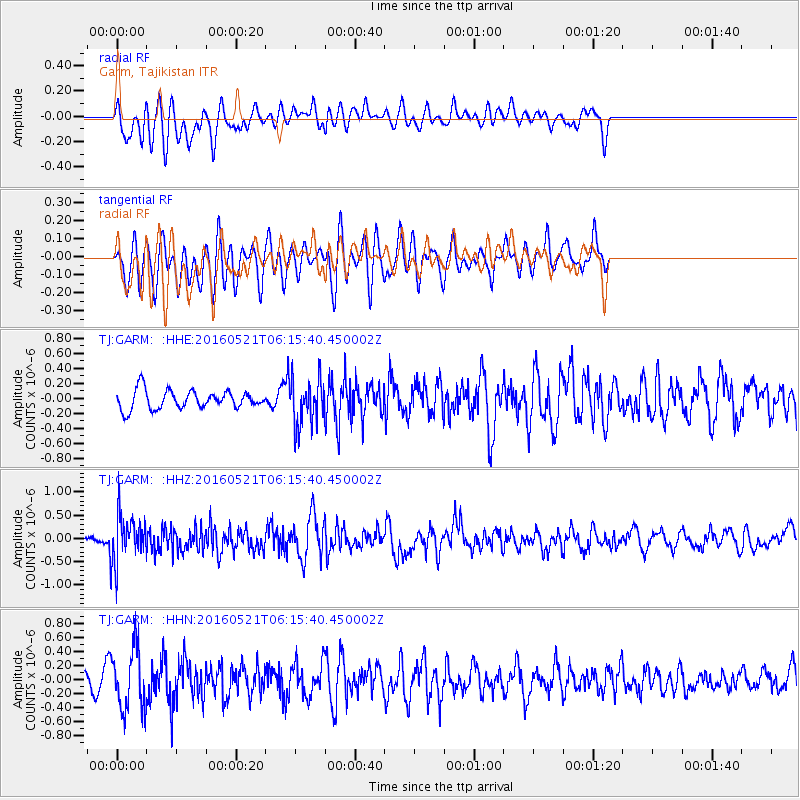
GARM Garm, Tajikistan - Earthquake Result Viewer
*The percent match for this event was below the threshold and hence no stack was calculated.
| Earthquake location: |
Southeast Of Honshu, Japan |
| Earthquake latitude/longitude: |
30.9/140.1 |
| Earthquake time(UTC): |
2016/05/21 (142) 06:06:42 GMT |
| Earthquake Depth: |
130 km |
| Earthquake Magnitude: |
5.5 MB |
| Earthquake Catalog/Contributor: |
NEIC PDE/NEIC COMCAT |
|
| Network: |
TJ Tajikistan National Seismic Network |
| Station: |
GARM Garm, Tajikistan |
| Lat/Lon: |
39.00 N/70.32 E |
| Elevation: |
1305 m |
|
| Distance: |
56.5 deg |
| Az: |
298.722 deg |
| Baz: |
75.258 deg |
| Ray Param: |
$rayparam |
*The percent match for this event was below the threshold and hence was not used in the summary stack. |
|
| Radial Match: |
62.730625 % |
| Radial Bump: |
400 |
| Transverse Match: |
54.903423 % |
| Transverse Bump: |
400 |
| SOD ConfigId: |
7422571 |
| Insert Time: |
2019-04-22 15:26:33.228 +0000 |
| GWidth: |
2.5 |
| Max Bumps: |
400 |
| Tol: |
0.001 |
|
Signal To Noise
| Channel | StoN | STA | LTA |
| TJ:GARM: :HHZ:20160521T06:15:40.450002Z | 2.8192194 | 5.059713E-7 | 1.7947212E-7 |
| TJ:GARM: :HHN:20160521T06:15:40.450002Z | 3.9869127 | 4.3719658E-7 | 1.09657925E-7 |
| TJ:GARM: :HHE:20160521T06:15:40.450002Z | 2.679003 | 3.310444E-7 | 1.2357E-7 |
| Arrivals |
| Ps | |
| PpPs | |
| PsPs/PpSs | |


