You are here: Home > Network List > UW - Pacific Northwest Regional Seismic Network Stations List
> Station PASS Maple Falls, WA, USA > Earthquake Result Viewer
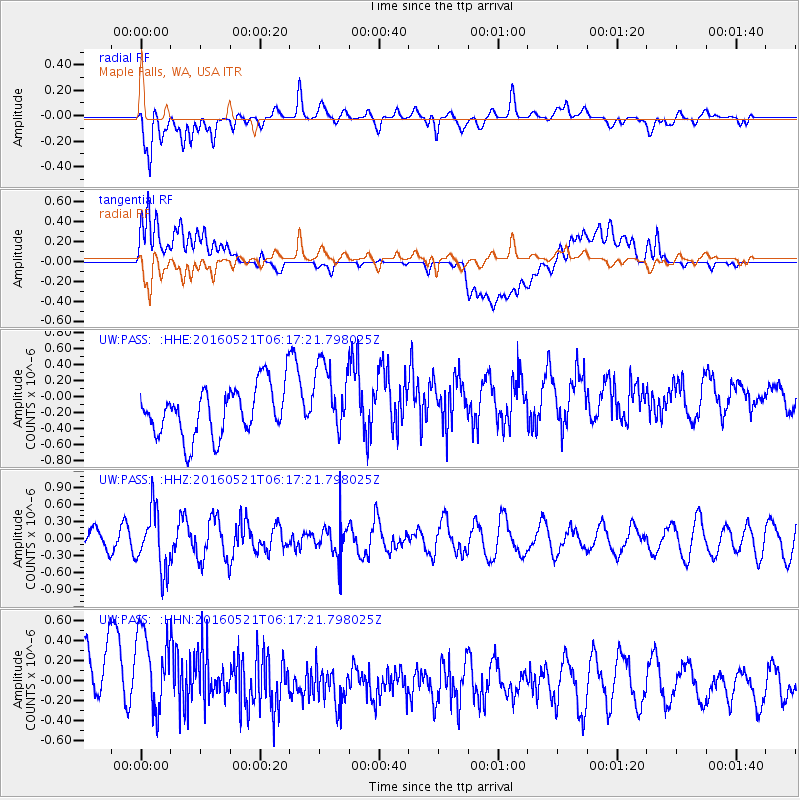
PASS Maple Falls, WA, USA - Earthquake Result Viewer
*The percent match for this event was below the threshold and hence no stack was calculated.
| Earthquake location: |
Southeast Of Honshu, Japan |
| Earthquake latitude/longitude: |
30.9/140.1 |
| Earthquake time(UTC): |
2016/05/21 (142) 06:06:42 GMT |
| Earthquake Depth: |
130 km |
| Earthquake Magnitude: |
5.5 MB |
| Earthquake Catalog/Contributor: |
NEIC PDE/NEIC COMCAT |
|
| Network: |
UW Pacific Northwest Regional Seismic Network |
| Station: |
PASS Maple Falls, WA, USA |
| Lat/Lon: |
49.00 N/122.09 W |
| Elevation: |
174 m |
|
| Distance: |
72.1 deg |
| Az: |
43.287 deg |
| Baz: |
296.544 deg |
| Ray Param: |
$rayparam |
*The percent match for this event was below the threshold and hence was not used in the summary stack. |
|
| Radial Match: |
59.156338 % |
| Radial Bump: |
400 |
| Transverse Match: |
56.22774 % |
| Transverse Bump: |
400 |
| SOD ConfigId: |
7422571 |
| Insert Time: |
2019-04-22 15:26:57.441 +0000 |
| GWidth: |
2.5 |
| Max Bumps: |
400 |
| Tol: |
0.001 |
|
Signal To Noise
| Channel | StoN | STA | LTA |
| UW:PASS: :HHZ:20160521T06:17:21.798025Z | 2.1698391 | 5.2474866E-7 | 2.418376E-7 |
| UW:PASS: :HHN:20160521T06:17:21.798025Z | 1.340707 | 5.689923E-7 | 4.2439717E-7 |
| UW:PASS: :HHE:20160521T06:17:21.798025Z | 1.4546665 | 4.5294388E-7 | 3.1137301E-7 |
| Arrivals |
| Ps | |
| PpPs | |
| PsPs/PpSs | |


