You are here: Home > Network List > TA - USArray Transportable Network (new EarthScope stations) Stations List
> Station H17A Grant Village (NPS), Yellowstone Nt. Park, WY, USA > Earthquake Result Viewer
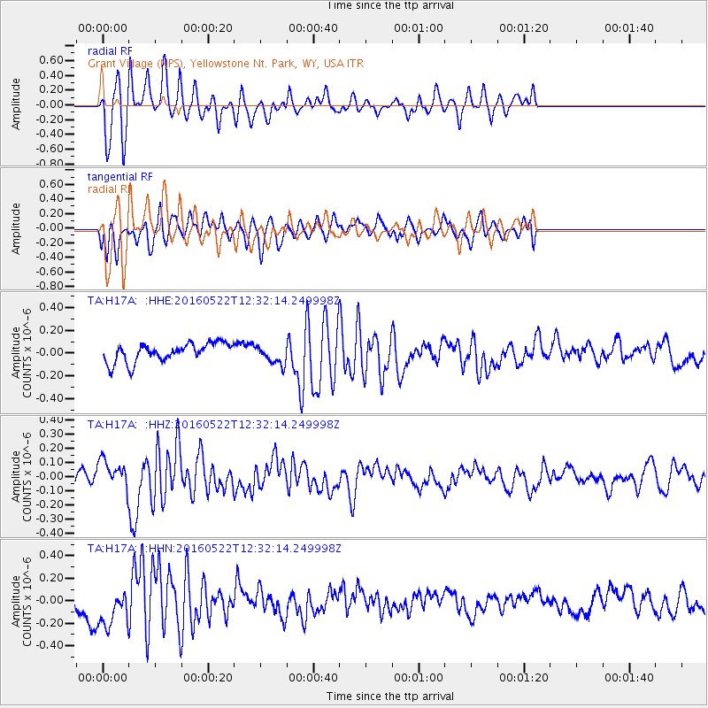
H17A Grant Village (NPS), Yellowstone Nt. Park, WY, USA - Earthquake Result Viewer
*The percent match for this event was below the threshold and hence no stack was calculated.
| Earthquake location: |
Salta Province, Argentina |
| Earthquake latitude/longitude: |
-22.4/-64.2 |
| Earthquake time(UTC): |
2016/05/22 (143) 12:20:42 GMT |
| Earthquake Depth: |
9.2 km |
| Earthquake Magnitude: |
5.5 MB |
| Earthquake Catalog/Contributor: |
NEIC PDE/NEIC COMCAT |
|
| Network: |
TA USArray Transportable Network (new EarthScope stations) |
| Station: |
H17A Grant Village (NPS), Yellowstone Nt. Park, WY, USA |
| Lat/Lon: |
44.40 N/110.58 W |
| Elevation: |
2400 m |
|
| Distance: |
78.8 deg |
| Az: |
328.067 deg |
| Baz: |
136.93 deg |
| Ray Param: |
$rayparam |
*The percent match for this event was below the threshold and hence was not used in the summary stack. |
|
| Radial Match: |
57.834583 % |
| Radial Bump: |
400 |
| Transverse Match: |
56.38884 % |
| Transverse Bump: |
400 |
| SOD ConfigId: |
7422571 |
| Insert Time: |
2019-04-22 15:35:23.263 +0000 |
| GWidth: |
2.5 |
| Max Bumps: |
400 |
| Tol: |
0.001 |
|
Signal To Noise
| Channel | StoN | STA | LTA |
| TA:H17A: :HHZ:20160522T12:32:14.249998Z | 3.0289912 | 1.06615595E-7 | 3.5198383E-8 |
| TA:H17A: :HHN:20160522T12:32:14.249998Z | 2.6803806 | 1.8587058E-7 | 6.934485E-8 |
| TA:H17A: :HHE:20160522T12:32:14.249998Z | 1.0353665 | 8.5547065E-8 | 8.2624915E-8 |
| Arrivals |
| Ps | |
| PpPs | |
| PsPs/PpSs | |


