You are here: Home > Network List > AC - Albanian Seismological Network Stations List
> Station LSK LSK > Earthquake Result Viewer
LSK LSK - Earthquake Result Viewer
| Earthquake location: |
Southeast Of Ryukyu Islands |
| Earthquake latitude/longitude: |
27.0/130.2 |
| Earthquake time(UTC): |
2016/05/27 (148) 03:44:29 GMT |
| Earthquake Depth: |
10 km |
| Earthquake Magnitude: |
5.8 MO |
| Earthquake Catalog/Contributor: |
NEIC PDE/NEIC ALERT |
|
| Network: |
AC Albanian Seismological Network |
| Station: |
LSK LSK |
| Lat/Lon: |
40.15 N/20.60 E |
| Elevation: |
960 m |
|
| Distance: |
86.5 deg |
| Az: |
313.663 deg |
| Baz: |
57.373 deg |
| Ray Param: |
0.04398449 |
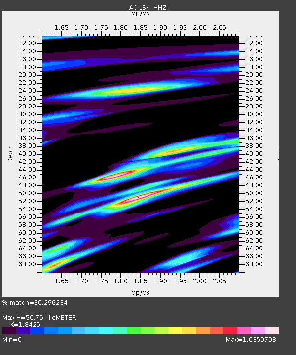
| Estimated Moho Depth: |
50.75 km |
| Estimated Crust Vp/Vs: |
1.84 |
| Assumed Crust Vp: |
6.291 km/s |
| Estimated Crust Vs: |
3.415 km/s |
| Estimated Crust Poisson's Ratio: |
0.29 |
|
| Radial Match: |
80.296234 % |
| Radial Bump: |
400 |
| Transverse Match: |
75.35733 % |
| Transverse Bump: |
400 |
| SOD ConfigId: |
7422571 |
| Insert Time: |
2019-04-22 15:47:41.168 +0000 |
| GWidth: |
2.5 |
| Max Bumps: |
400 |
| Tol: |
0.001 |
|

Signal To Noise
| Channel | StoN | STA | LTA |
| AC:LSK: :HHZ:20160527T03:56:40.830017Z | 3.9331777 | 2.5070915E-7 | 6.374214E-8 |
| AC:LSK: :HHN:20160527T03:56:40.830017Z | 1.2665149 | 1.0918488E-7 | 8.620893E-8 |
| AC:LSK: :HHE:20160527T03:56:40.830017Z | 1.5576466 | 1.1522493E-7 | 7.397373E-8 |
| Arrivals |
| Ps | 6.9 SECOND |
| PpPs | 22 SECOND |
| PsPs/PpSs | 29 SECOND |


