You are here: Home > Network List > HT - Aristotle University of Thessaloniki Seismological Network Stations List
> Station LIT Litochoro, Greece, HT-Net > Earthquake Result Viewer
LIT Litochoro, Greece, HT-Net - Earthquake Result Viewer
| Earthquake location: |
Southeast Of Ryukyu Islands |
| Earthquake latitude/longitude: |
27.0/130.2 |
| Earthquake time(UTC): |
2016/05/27 (148) 03:44:29 GMT |
| Earthquake Depth: |
10 km |
| Earthquake Magnitude: |
5.8 MO |
| Earthquake Catalog/Contributor: |
NEIC PDE/NEIC ALERT |
|
| Network: |
HT Aristotle University of Thessaloniki Seismological Network |
| Station: |
LIT Litochoro, Greece, HT-Net |
| Lat/Lon: |
40.10 N/22.49 E |
| Elevation: |
480 m |
|
| Distance: |
85.3 deg |
| Az: |
312.85 deg |
| Baz: |
58.529 deg |
| Ray Param: |
0.04484287 |
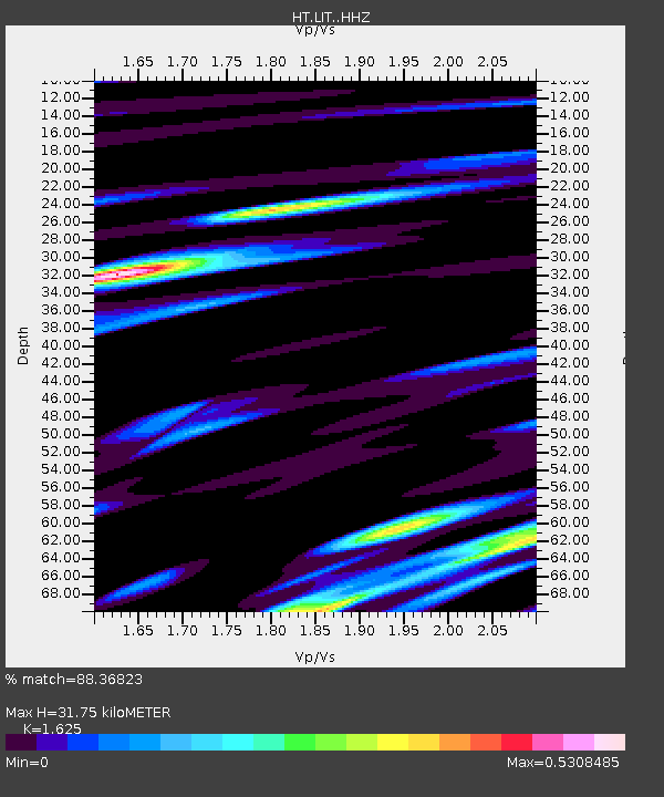
| Estimated Moho Depth: |
31.75 km |
| Estimated Crust Vp/Vs: |
1.62 |
| Assumed Crust Vp: |
6.279 km/s |
| Estimated Crust Vs: |
3.864 km/s |
| Estimated Crust Poisson's Ratio: |
0.20 |
|
| Radial Match: |
88.36823 % |
| Radial Bump: |
400 |
| Transverse Match: |
46.539448 % |
| Transverse Bump: |
400 |
| SOD ConfigId: |
7422571 |
| Insert Time: |
2019-04-22 15:52:07.331 +0000 |
| GWidth: |
2.5 |
| Max Bumps: |
400 |
| Tol: |
0.001 |
|

Signal To Noise
| Channel | StoN | STA | LTA |
| HT:LIT: :HHZ:20160527T03:56:34.900024Z | 9.174722 | 8.0177915E-7 | 8.739003E-8 |
| HT:LIT: :HHN:20160527T03:56:34.900024Z | 2.1687603 | 3.9557221E-7 | 1.8239554E-7 |
| HT:LIT: :HHE:20160527T03:56:34.900024Z | 2.1681478 | 2.5439203E-7 | 1.1733151E-7 |
| Arrivals |
| Ps | 3.2 SECOND |
| PpPs | 13 SECOND |
| PsPs/PpSs | 16 SECOND |


